Discover Gunung Stong in Dabong, Kelantan—home to Asia’s tallest waterfall, lush rainforest trails, and breathtaking campsites. This complete guide covers trekking routes, facilities, attractions, and booking info for your next adventure.
Why Visit
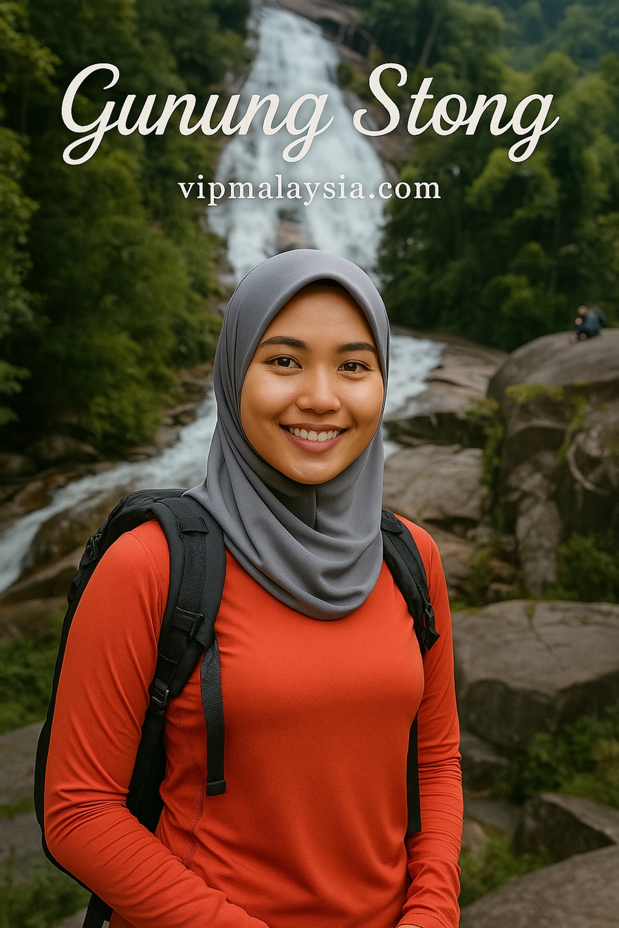
Gunung Stong isn’t just a mountain—it’s a sanctuary of nature, culture, and challenge. Located in Dabong, Kelantan, this highland escape offers a rare blend of cascading waterfalls, mystical caves, and rugged trails. Whether you’re a seasoned hiker or a curious explorer, Gunung Stong promises an unforgettable journey into Malaysia’s wild heart.
Trekking & Trails
Baha’s Camp Trail
Start from Jelawang Resort (666 ft elevation)
Reach Baha’s Camp in 45 minutes
Explore nearby caves and waterfalls
Sumalian Trail
Off-track route through Semeliang Valley
Visit Taman Orkid, Gua Kelawar, Gua Kayu Jadi Batu
Encounter rare orchids and fossilized wood
Gunung Ayam & Gunung Stong Expedition
Begin at Baha’s Camp at sunrise
Reach Gunung Stong peak by midday
Continue to Gunung Ayam via Beta Balak (2652 ft)
Camp near bonsai trees and enjoy sunset views
Visitor Reviews & Testimonials
“Gunung Stong is a dream for nature lovers. The waterfall is majestic and the trails are challenging but rewarding.” – Amir, hiker from Kuala Lumpur
“I’ve never seen a sunrise like the one from Jelawang Waterfall. The view from Baha’s Camp is magical.” – Siti, backpacker from Penang
“The Sumalian Trail was tough but worth it. Gua Kayu Jadi Batu is unlike anything I’ve seen.” – Lela, adventure seeker
Quick Info: Gunung Stong Overview
Attribute
Details
Location Name
Gunung Stong
Address
Hutan Simpan Gunung Stong Tengah, Dabong, Kelantan
GPS Coordinates
WGS 84 : N5.3396°, E101.9749°
State
Kelantan
Height
1433 meters
Main Waterfall
Jelawang Waterfall – 305 meters (tallest in Southeast Asia)
Nearby Peaks
Gunung Ayam, Puncak Baha
Popular Trails
Baha’s Camp Trail, Sumalian Trail
Natural Attractions
Gua Rantai, Kolam Puteri, Telaga Tujuh, Air Terjun Dua Gunung
Camping Capacity
Up to 200 people (2 designated sites)
Facilities
Parking, toilets, surau, chalet, rest huts, jogging track, cooking area
Nearby Town
Dabong (accessible by train)
Transport Options
Train, boat, van, taxi, bus
Distance from Jeli
46 km
Distance from Kuala Krai
84 km
Emergency Contacts
911, Jeli Health Office (609-9440 333), Jeli Police HQ (609-7867 222), Jeli Fire Station (609-9440 444)
Park Status
State Park under National Forestry Act 1984
Contact & Booking Information
Organization
Address & Contact
LEMBAGA KEMAJUAN KELANTAN SELATAN (KESEDAR)
Bandar Baru Gua Musang, 18300 Gua Musang, Kelantan Darul Naim, Malaysia Tel: 609-9132200 Fax: 609-9121211 Email: kesgm@kesedar.gov.my
Forestry Department of Peninsular Malaysia
Jalan Sultan Salahuddin, 50660 Kuala Lumpur Tel: 603-26164488 Fax: 603-26925657 Email: webmaster@forestry.gov.my
Malaysia Biodiversity Information System (MyBIS)
Biodiversity and Forestry Management Division, Ministry of NRES, Level 6, Block F11, Kompleks F, Presint 1, 62000 Putrajaya, Malaysia Email: hello.mybis@nres.gov.my
WWF-Malaysia Offices
Semenanjung Malaysia:
No. 1 Jalan PJS 5/28A, PJCC 46150 Petaling Jaya, Selangor, Malaysia Tel: +603 7450 3773 Fax: +603 7450 3777
Sabah:
6th Floor, CPS Tower, Centre Point Complex, Kota Kinabalu 88800 Sabah Tel: +6088 262 420 Fax: +6088 242 531
Sarawak:
7th Floor, Bangunan Binamas, Lot 138, Section 54, Jalan Padungan, Kuching 93100 Sarawak Tel: +6082 247 420 / 257 420 Fax: +6082 241 531 Email: contactus@wwf.org.my
Stong Heritage Eco Resort
Gunung Stong, Dabong, Malaysia Tel: 013-838 3828
Final Thoughts
Gunung Stong is more than a mountain—it’s a living canvas of Malaysia’s natural wonders. From cascading waterfalls and mystical caves to bonsai-covered peaks and off-track jungle trails, this destination offers a rare blend of serenity and adventure. Whether you’re camping under the stars or chasing waterfalls, Gunung Stong will leave you breathless—in the best way.
Ready to conquer Kelantan’s crown jewel? Pack your boots, book your spot, and let Gunung Stong elevate your spirit.
Summary
Attraction: Gunung Stong
Location: #Kelantan
Attraction Type: #Mount
Best Destinations in Kelantan
Discover the best destinations in Kelantan—from the majestic waterfalls of Gunung Stong to the cultural treasures of Kota Bharu. Whether you’re drawn to royal heritage, jungle adventures, or serene beaches, this guide unveils Kelantan’s most unforgettable experiences. Click now to plan your perfect East Coast escape!
Tok Bali Dreaming of golden sands and soothing tides? Tok Bali offers more than just beach bliss—it’s a living postcard of marine culture, peaceful retreats,…
Pantai Bisikan Bayu Escape to the soulful shores of Pantai Bisikan Bayu, where wind whispers through casuarina trees and waves invite you to relax, play,…
Masjid Sultan Muhammad II, Telipot Built in 1978, Masjid Sultan Muhammad II—formerly known as Masjid Telipot—is a mosque of elegance, cultural depth, and spiritual significance….
Masjid Ar-Rahman Masjid Ar-Rahman, located in Pulau Gajah, Kelantan, is more than a mosque—it’s a testament to spiritual dedication and global design influences. Built between…
Wat Mai Suwankiri Nestled in the lush district of Tumpat, Kelantan, Wat Mai Suwankiri is a stunning Thai Buddhist temple that celebrates tradition, artistry, and…
Looking for travel inspiration, delicious recipes, or the best places to eat? Want to stay updated on smart financial tips, personal loan promotions, or the latest car models? Whether you’re searching for hobby ideas, product reviews, or something new, we’ve got you covered! Click on the links, explore exciting insights, and let your next discovery begin—it’s just one click away!
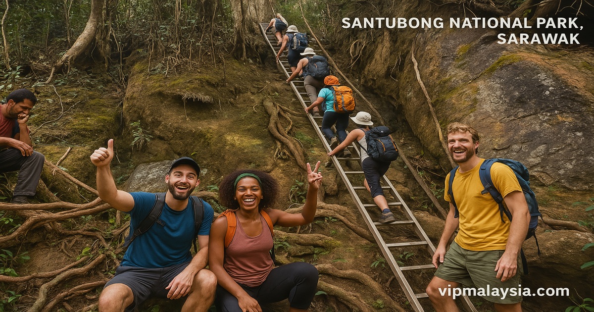
Just 35km from Kuching, Santubong National Park beckons with its legendary summit, cascading waterfalls, and jungle trails that test your spirit and reward you with breathtaking views of the South China Sea. Whether you’re up for a steep climb or curious about the mythical princess of Santubong, this park offers more than just nature—it’s an experience that empowers adventurers and respects conservation.
Why Visit
Mountain Majesty with Coastal Flair
Gunung Santubong rises to 810 meters, wrapping the Damai Peninsula in rainforest charm and dramatic rock formations. It’s a one-day trek with the thrill of rope ladders, wild fauna, and panoramic sea views. On clear days, its jagged silhouette is visible from Kuching.
More Than Just a Walk in the Park
Trekkers can cool off in a stunning waterfall at the end of the trail. And if you ask a local about the story of Princess Santubong, you’ll uncover ancient folklore woven into the land itself.
Trail Highlights and Park Experience
Santubong Summit Adventure
Trail includes steep ascents and rope-assisted climbs
Features dense rainforest, resting points, rock segments near the peak
Descent ends with a refreshing waterfall
Strict cut-off time: Visitors must reach endpoint by 3:30 PM
Wildlife & Scenic Views
Catch glimpses of local flora and fauna
Spectacular view over the South China Sea
No birdwatching or jungle trekking permitted during monsoon season
Local Tour Provider – Paradesa Borneo
Trip Details
Price: Adults (MYR 470), Children (MYR 235)
Duration: 5–8 hours
Departure Time: 8:00 AM
Availability: Year-round
Group Size: Minimum 2 adults
Difficulty Level: High – steep climbs, ropes, and ladders
Monsoon season (No activities allowed until March 2024)
Facilities
No accommodation or cafeteria
Permit Info
Required for professional photography/filming
Operating Hours
Park: 8:00 AM – 5:00 PM Daily (incl. Public Holidays)
How to Get There
30 min drive from Kuching to park entrance
User Reviews & Testimonials
“The climb is no joke, but once you’re up there, the view over the South China Sea is soul-refreshing. Don’t forget to pack a towel for the waterfall!” – Isabelle M., Penang
“My guide explained the legend of Princess Santubong as we hiked—it added so much magic to the trek. Worth every step!” – Dan R., Australia
Tour Package
Attribute
Details
Tour Name
Mount Santubong Summit Hike – Paradesa Borneo
Price
Adults (12+): MYR 470.00
Children (9–11): MYR 235.00
Departure Time
08:00 hrs
Meeting Point
Hostel/hotel pick-up
Availability
Year-round, Monday to Sunday
Duration
5 to 8 hours
Group Size
Minimum 2 adults
Difficulty Level
Good fitness required for steep climbs
Included
Packed lunch, refreshments, transfer, local English-speaking guide, challenging hike
What to Bring
Light, quick-dry clothing
Swimsuits or shorts
Comfortable walking shoes (no flip-flops)
Insect repellent, sunscreen, antiseptic
Towel, change of clothes, raincoat/poncho
Dry bag for electronics
Sun hat/cap, sunglasses
Extra snacks and drinks
About Your Guide
One passionate local English-speaking guide for up to 8 guests, sharing deep knowledge and answering questions throughout the trek
Uncover the best destinations in Sarawak—from the breathtaking peaks of Mount Kinabalu to the pristine shores of Sipadan Island. Whether you’re chasing wildlife encounters, cultural gems, or tropical escapes, this guide reveals the most unmissable adventures. Click now to plan your perfect Sabah getaway!
Sibu Central Market Step into the heart of Sibu and discover Sibu Central Market—a bustling indoor bazaar that blends tradition, taste, and local charm. With…
Satok Weekend Market Step into the bustling lanes of Satok Weekend Market, where native Sarawakian vendors, Chinese and Malay traders, and curious travelers converge in…
Santubong National Park Just 35km from Kuching, Santubong National Park beckons with its legendary summit, cascading waterfalls, and jungle trails that test your spirit and…
Talang Satang National Park Cradled off the coast of Sarawak, Malaysia, Talang Satang National Park is a stunning marine sanctuary created to protect endangered sea…
Piasau Nature Reserve Nestled in Miri, Sarawak, Piasau Nature Reserve is a shining example of ecological transformation. Once an oil camp, now a thriving sanctuary,…
Borneo Happy Farm Nestled amidst the hills of Kuching, Borneo Happy Farm isn’t just another attraction—it’s a living, breathing showcase of sustainable farming, endangered wildlife,…
Irrawaddy Dolphin Watching Set sail through the lush mangrove forests of Kuching Wetlands National Park and witness the elusive Irrawaddy dolphins in action. This unforgettable…
Matang Wildlife Centre Matang Wildlife Centre, located on the edge of Kubah National Park in Sarawak, is a rehabilitative haven—not a zoo—where rescued orangutans and…
Looking for travel inspiration, delicious recipes, or the best places to eat? Want to stay updated on smart financial tips, personal loan promotions, or the latest car models? Whether you’re searching for hobby ideas, product reviews, or something new, we’ve got you covered! Click on the links, explore exciting insights, and let your next discovery begin—it’s just one click away!
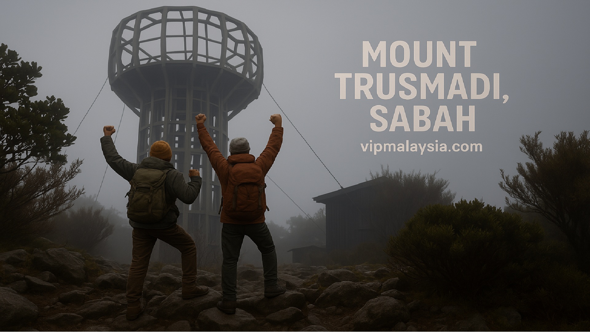
Gunung Trusmadi, Sabah’s second tallest peak, is a rugged mountain that challenges even seasoned hikers. Rising to 2,642 meters, it offers rare biodiversity, panoramic views of Mount Kinabalu, and an unforgettable wilderness adventure.
Introduction
If Mount Kinabalu is the crown of Malaysia, Gunung Trusmadi is the challenge. Located in Sabah’s interior, this mountain stands at 2,642 meters above sea level, making it the second highest peak in the country. Unlike Kinabalu’s well‑trodden paths, Trusmadi’s trails are raw, steep, and demanding, rewarding climbers with pristine rainforest, endemic flora, and breathtaking sunrise views of Kinabalu itself. For those seeking a more remote and authentic trekking experience, Trusmadi is calling.
History
Gunung Trusmadi’s history is deeply tied to the indigenous communities of Sabah. The Kadazan Dusun people call it Nulu Trusmadi, meaning “mountain of Trusmadi.” For centuries, the mountain was revered as a sacred site, believed to be home to spirits that guarded the forest. During the colonial era, British explorers documented its rugged terrain and unique biodiversity, but it remained largely untouched compared to Kinabalu.
In the 1980s, the Sabah Forestry Department designated the Trusmadi Forest Reserve, covering 184,527 hectares, to protect its rich ecosystems. This move safeguarded rare species such as the Nepenthes × trusmadiensis, a hybrid pitcher plant found nowhere else on Earth. Today, Trusmadi is recognized not only as a trekking destination but also as a biodiversity hotspot, attracting researchers, conservationists, and adventurers alike.
Highlights
The Second Tallest but Toughest
Gunung Trusmadi may not surpass Kinabalu in height, but many hikers agree it is far more grueling. Trails are steep, muddy, and less developed, demanding endurance and resilience. The reward is solitude and a sense of raw adventure that Kinabalu’s crowded summit cannot match.
Gunung Trusmadi is Malaysia’s second highest peak at 2,642 m, while Mount Kinabalu towers at 4,095 m. Kinabalu is taller and more accessible, but Trusmadi is widely regarded as the tougher climb due to its undeveloped trails and raw jungle conditions.
Gunung Trusmadi vs Mount Kinabalu
Aspect
Gunung Trusmadi
Mount Kinabalu
Height
2,642 m (8,668 ft), second highest in Malaysia
4,095 m (13,435 ft), tallest in Malaysia
Difficulty
Considered tougher: muddy, steep, narrow trails, vertical climbs, less infrastructure
Challenging mainly due to altitude and long stair climbs; trails are well-maintained
Trails
Three main routes: Kaingaran (5.0 km), Mastan (4.4 km), Mannan (11.5 km)
Standard route via Timpohon Gate; alternative Mesilau trail (longer, scenic)
Biodiversity
Rich flora and fauna, five vegetation zones, endemic pitcher plant Nepenthes × trusmadiensis
Kinabalu Park UNESCO site, over 5,000 plant species, orchids, and endemic animals
Facilities
Basic rest houses and campsites; limited amenities, requires guides and permits
Well-developed lodges, rest houses, and organized climbing packages
Popularity
Less crowded, appeals to seasoned hikers seeking solitude and challenge
Highly popular, attracts thousands annually, more accessible for casual climbers
Summit Views
Panoramic sunrise view of Mount Kinabalu ~40 km north
Expansive views across Sabah and South China Sea
Biodiversity Wonderland
The mountain features five vegetation zones: lowland dipterocarp, hill dipterocarp, lower montane, upper montane, and summit scrub. Each zone hosts unique wildlife, from hornbills and gibbons in the lowlands to orchids and mosses in the upper montane. The highlight is the endemic Nepenthes × trusmadiensis, a rare pitcher plant hybrid that thrives only here.
Attractions
Sunrise Views of Mount Kinabalu
One of the most magical experiences is witnessing Mount Kinabalu glowing at sunrise from Trusmadi’s summit. On clear mornings, the view is unforgettable, with Kinabalu’s jagged silhouette framed by misty valleys.
Rare Flora and Fauna
Trusmadi is home to clouded leopards, barking deer, and hornbills, alongside countless orchids and ferns. Its forests are a living museum of Bornean biodiversity.
Cultural Encounters
Nearby towns such as Tambunan and Keningau host Kadazan Dusun festivals, where visitors can experience traditional dances, rice wine (tapai), and local crafts.
Climb Packages
2D1N Climb
Perfect for experienced trekkers short on time
Includes: overnight stay, licensed guides, meals
Pickup: Your hotel in Kota Kinabalu
3D2N Climb
Extra night in Tambunan to prep and rest
Ideal for: Better acclimatization, scenic detours
4D3N Climb via Sinua Trail
Longest and most immersive option
A test of endurance for the seasoned adventurer
Things to Do
Trekking and Hiking
Gunung Trusmadi offers three main summit trails — Kaingaran, Mastan, and Mannan — each with distinct challenges and experiences. Kaingaran is the most developed, Mastan is steep and rugged, while Mannan is the longest and most immersive rainforest trek.
Wayaan Kaingaran (Tambunan)
The Kaingaran Trail is the oldest and most established route to Gunung Trusmadi’s summit. Stretching 5.0 km, it typically requires 2 days and 1 night to complete. The trail begins with a scenic 3 km elevated boardwalk through montane forest, offering opportunities to spot orchids, pitcher plants, and birdlife. Midway, climbers rest at Walai Tingkoyodon Rest House, which provides electricity, water supply, toilets, and basic lodging for up to 20 people. This makes Kaingaran the most accessible and tourist‑friendly option, though a 4WD vehicle is required to reach the trailhead from Tambunan.
The final stretch to the summit is steeper, requiring stamina and determination, but climbers are rewarded with panoramic views of Mount Kinabalu at sunrise. Because of its infrastructure and relative ease compared to other trails, Kaingaran is often recommended for first‑time climbers of Trusmadi who still want a challenging but manageable adventure.
Wayaan Mastan (Keningau)
The Mastan Trail from Keningau is the shortest at 4.4 km, but it is also the steepest and most demanding. Climbers usually complete it in 2 days and 1 night, starting from Apin‑Apin base camp. Unlike Kaingaran, Mastan is less developed, with minimal facilities, making it a raw jungle experience. The trail is known for its vertical climbs and muddy paths, requiring good physical fitness and preparation.
Authorities limit the Mastan trail to 30 climbers per day to reduce environmental impact and preserve its wilderness. Along the way, trekkers encounter unique spots such as Pagandadan Ranjers and Taman H.S. Martyn, which showcase diverse flora and fauna. This trail is ideal for seasoned hikers seeking a tougher challenge and solitude away from more popular routes.
Wayaan Mannan (Sinua, Sook)
The Mannan Trail is the longest and most immersive, covering 11.5 km and requiring 4 days and 3 nights to complete. Starting from Sinua village in Sook, the trail is accessible by good roads, eliminating the need for 4WD vehicles. Climbers traverse dense rainforest, cross streams, and camp at designated sites such as Camp 1 and Camp 2, which provide basic facilities like hammocks, running water, and toilets.
This route is renowned for its rich biodiversity, with sightings of exotic orchids, pitcher plants, hornbills, and even waterfalls such as Waig Nakalabai. The longer duration allows trekkers to acclimatize to altitude and fully immerse themselves in the wilderness. Mannan is best suited for experienced adventurers who want a deep rainforest journey and are prepared for endurance challenges.
Birdwatching and Wildlife Spotting
Trusmadi’s forests are a paradise for birdwatchers, with sightings of Bornean bristleheads, hornbills, and kingfishers. Mammals such as civets and macaques are also common.
Eco‑Tourism and Conservation
Visitors can join guided tours that highlight conservation efforts, learning about forest protection and sustainable tourism practices.
Nearby Attractions
Tambunan Town
Known as the “Switzerland of Sabah,” Tambunan is surrounded by paddy fields and rolling hills. Visitors can explore the Tambunan Rafflesia Reserve, home to the world’s largest flower.
Keningau Town
A bustling town with markets, cultural festivals, and access to the Crocker Range. It is a gateway for trekkers heading to Trusmadi via the Mastan trail.
Sinua Village
Located near Sook, Sinua offers a glimpse into rural Sabah life. Visitors can experience homestays, local cuisine, and traditional farming practices.
Conclusion
For those who seek more than just another summit photo, Gunung Trusmadi offers something deeper: solitude, struggle, and a rare communion with nature. Whether you’re drawn by its elusive pitcher plants or its reputation as the tougher Kinabalu, this mountain will test—and transform—you.
Book your expedition to Gunung Trusmadi today and redefine what adventure means to you. For bookings, permits, or guided packages, contact the forestry officers or Amazing Borneo Tours.
Summary
Attraction: Gunung Trusmadi
Location: #Sabah
Attraction Type: #Mount
Climbing Contacts & Forestry Approvals
Route / Contact
Details
Notes
Wayaan Kaingaran – Tambunan
District Forest Officer: Mr. Saleh Intang Address: Peti Surat No. 64, 89657 Tambunan E‑Mail: saleh.intang@sabah.gov.my Telephone: +60 88 899 589
Official forestry contact for Kaingaran trail permits and coordination
Wayaan Mastan & Mannan – Keningau / Sook
District Forest Officer: Mr. Azman Said Address: Peti Surat No. 88, 89007 Keningau E‑Mail: azman.said@sabah.gov.my Telephone: +60 87 331 203 / +60 87 338 721
Handles permits and trail management for Mastan and Mannan routes
Operator – Amazing Borneo Tours
Amazing Borneo Tours & Events Sdn. Bhd. Address: Lot 1‑39, Kompeks Asia City, Kota Kinabalu E‑Mail: info@mounttrusmadi.com Telephone: +60 17‑262 2009
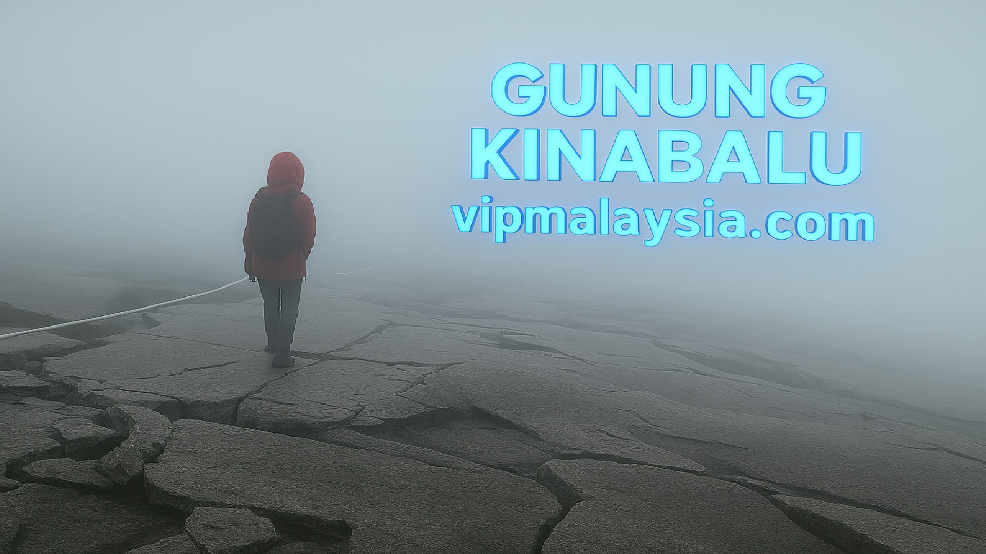
Ready for an unforgettable journey above the clouds? Gunung Kinabalu, Malaysia’s highest peak, offers more than just a climb—it’s a life-changing experience in the heart of Malaysian Borneo. Discover everything you need to plan, prepare, and say “I made it to the top.”
Introduction
Gunung Kinabalu, rising 4,095 meters above sea level, is Malaysia’s highest mountain and one of Southeast Asia’s most iconic natural wonders. Nestled within Kinabalu Park in Sabah, this UNESCO World Heritage Site offers breathtaking biodiversity, cultural heritage, and unforgettable trekking adventures.
History
The history of Gunung Kinabalu is deeply intertwined with the indigenous Kadazan-Dusun people, who regard the mountain as sacred. According to local legend, the spirits of ancestors dwell on its slopes, making it a place of reverence and ritual. The name “Kinabalu” is believed to derive from “Aki Nabalu,” meaning “Revered Place of the Dead.”
European explorers first documented the mountain in the mid-19th century, with Sir Hugh Low leading the earliest recorded ascent in 1851. His name lives on at Low’s Peak, the highest point of the mountain. Over time, Gunung Kinabalu became a focal point for scientific research due to its extraordinary biodiversity. In 1964, Kinabalu Park was established to protect this ecological treasure, and in 2000, UNESCO recognized it as a World Heritage Site.
Getting There
Gunung Kinabalu is located within Kinabalu Park, near Kundasang, about two hours by car from Kota Kinabalu, the capital of Sabah. The park headquarters at Timpohon Gate serves as the main entry point for climbers.
Travelers typically fly into Kota Kinabalu International Airport (BKI), then continue by taxi, rental car, or tour bus to the park. The journey itself is scenic, passing through rolling hills and villages before reaching the cooler highlands.
How to Get There
Most treks begin early from Timpohon Gate, the standard trailhead. The Mesilau Trail was once an alternative but has been closed since the 2015 earthquake.
Permits, guides, and accommodations must be booked in advance through Kinabalu Park HQ. This ensures climbers are registered, guided safely, and provided with lodging at Panalaban (formerly Laban Rata).
When to Go
The best months to climb are March to August, during Sabah’s drier season. Weather is more stable, though mountain conditions remain unpredictable.
Booking ahead is essential, as daily climber numbers are limited to protect the environment. A licensed mountain guide is mandatory, and accommodations at Panalaban fill quickly during peak season.
Climb Itenary
Day / Stage
Details
Duration & Difficulty
Day 1: Arrival at Kinabalu Park HQ
Register at Park HQ, secure permits, meet certified guide. Begin trek at Timpohon Gate (1,866 m). First stop at Carson Falls, then continue through forest huts (Kandis, Ubah, Lowii, Mempening). Overnight at Panalaban Resthouse (formerly Laban Rata) at 3,272 m.
6–8 hours trekking. Moderate to strenuous; altitude gain ~1,400 m.
Day 2: Summit Push (Low’s Peak)
Wake at ~2:00 AM. Begin steep ascent over granite slabs with fixed ropes. Reach Low’s Peak (4,095 m) at sunrise. Descend back to Panalaban for breakfast, then continue down to Park HQ.
Mandatory overnight at Panalaban Resthouse (altitude lodging with meals).
1 night minimum stay required.
Difficulty Level
Considered moderate to strenuous. Requires fitness, stamina, and acclimatization.
Summit push is the hardest section; descent often tougher on knees.
Total Duration
Standard climb is 2 days, 1 night. Extended itineraries may include extra acclimatization hikes in Kinabalu Park.
2D1N standard; optional 3D2N for slower pace.
Highlights
The Summit Experience
Standing at 4,095 meters, Low’s Peak offers panoramic views that stretch across Sabah and, on clear days, even toward the South China Sea. The sunrise from the summit is considered one of the most spectacular in Asia.
Biodiversity Wonderland
Gunung Kinabalu is home to over 5,000 plant species, including orchids, pitcher plants, and the giant Rafflesia. The mountain also shelters 326 bird species and 100+ mammals, making it a living museum of biodiversity.
Cultural Significance
For the Kadazan-Dusun, Gunung Kinabalu is a sacred site. Rituals and traditions tied to the mountain continue to this day, reinforcing its role as a cultural landmark.
Extraordinary Flora
Nepenthes Rajah
Nepenthes rajah is the world’s largest pitcher plant, endemic to Mount Kinabalu. Its traps can hold over a liter of fluid and have been known to capture not only insects but also small vertebrates like frogs and even rats. This carnivorous plant thrives in nutrient-poor soils, supplementing its diet with prey digestion. Its ecological role is fascinating, as it also forms symbiotic relationships with tree shrews that feed on nectar while fertilizing the plant with droppings.
The plant’s striking size and adaptation make it a symbol of Kinabalu’s unique biodiversity. Conservationists emphasize its vulnerability to habitat loss and illegal collection, making protection within Kinabalu Park essential.
Paphiopedilum Rothschildianum
Known as the “Kinabalu Gold,” Paphiopedilum rothschildianum is one of the rarest orchids in the world. It grows exclusively on Kinabalu’s limestone cliffs and is distinguished by its striped petals and elegant slipper-shaped blooms. This orchid can take up to 15 years to flower, adding to its rarity and value.
Its beauty has unfortunately made it a target for illegal trade, with specimens fetching thousands of dollars on the black market. Strict conservation measures are in place to protect this orchid, which is considered a crown jewel of Kinabalu’s flora.
Rafflesia Keithii
Rafflesia keithii is one of the two Rafflesia species found in Kinabalu Park. It produces enormous flowers up to 80 cm in diameter, with a distinctive foul odor that attracts carrion flies for pollination. This parasitic plant lacks leaves, stems, and roots, living entirely off its host vine.
Despite its unpleasant smell, Rafflesia keithii is a major attraction for visitors. Its unpredictable blooming cycle makes sightings rare, adding to its mystique and allure.
Rhododendron Lowii
Rhododendron lowii is a spectacular species discovered by Sir Hugh Low, after whom Kinabalu’s summit is named. It produces large golden-yellow flower clusters that glow in the misty montane forests.
This rhododendron thrives in cloud forests above 2,200 meters, where mist and moisture dominate. Its vibrant blooms are a highlight for trekkers, symbolizing the mountain’s rich floral diversity.
Nepenthes Villosa
Nepenthes villosa is another rare pitcher plant found at higher altitudes of Kinabalu. It is adapted to colder, harsher conditions and features hairy pitchers with serrated peristomes.
This species is particularly vulnerable due to its limited distribution. Its survival depends on the unique microclimates created by Kinabalu’s granite slopes.
Dacrydium Gibbsiae
Dacrydium gibbsiae is a rare conifer endemic to Kinabalu’s montane forests. It thrives in cooler climates above 1,200 meters, forming part of the oak-chestnut forest ecosystem.
Its presence highlights Kinabalu’s role as a hub for conifer diversity in Southeast Asia. The species contributes to the ecological balance by providing habitat and food for wildlife.
Rhododendron Ericoides
Rhododendron ericoides is a heath rhododendron found in Kinabalu’s subalpine zones. Its scarlet, thimble-sized flowers bloom in thickets, creating vibrant displays in March and April.
This hardy shrub thrives in harsh conditions, with gnarled branches adapted to withstand strong winds and poor soils. Its resilience symbolizes the adaptability of Kinabalu’s flora.
Nepenthes Edwardsiana
Nepenthes edwardsiana is considered one of the most beautiful pitcher plants, with strikingly ribbed peristomes and vivid coloration. It is endemic to Kinabalu and nearby mountains.
Its rarity and aesthetic appeal make it highly sought after by collectors, but strict protection ensures its survival within Kinabalu Park.
Phyllocladus Hypophyllus
Phyllocladus hypophyllus is a unique conifer found in Kinabalu’s montane forests. Unlike typical conifers, it has flattened leaf-like structures called phylloclades.
This adaptation allows it to thrive in misty, nutrient-poor environments. Its unusual morphology makes it a fascinating subject for botanists studying evolutionary adaptations.
Rhododendron Buxifolium
Rhododendron buxifolium, or box-leaved rhododendron, grows in Kinabalu’s subalpine meadows. Its larger red flowers bloom spectacularly in spring, adding bursts of color to the high-altitude landscape.
This species is well adapted to soggy patches and rocky crevices, showcasing the resilience of Kinabalu’s alpine vegetation.
Rarest Fauna
Thomas’ Pygmy Squirrel
Thomas’ pygmy squirrel is one of the smallest squirrels in the world, measuring only about 7 cm in body length. Endemic to Kinabalu Park, it is often seen darting among mossy branches in montane forests. Its tiny size and rapid movements make it a challenge to spot, but it plays an important role in seed dispersal.
This species is considered vulnerable due to its restricted range. Conservation within Kinabalu Park ensures its survival, as deforestation outside protected areas threatens its delicate habitat.
Kinabalu Shrew
The Kinabalu shrew is a rare insectivorous mammal found only on Mount Kinabalu. It thrives in the cool, moist conditions of the montane forest floor, feeding on insects and small invertebrates. Its dark fur and small size make it well adapted to the dense undergrowth.
Because of its limited distribution, the Kinabalu shrew is highly vulnerable to environmental changes. Researchers emphasize its importance as an indicator species for ecosystem health in high-altitude habitats.
Mountain Blackbird
The mountain blackbird is a common sight near the summit of Gunung Kinabalu. This bird is adapted to high-altitude conditions, feeding on insects and berries found in alpine vegetation. Its dark plumage contrasts beautifully against the granite backdrop of the mountain.
Birdwatchers often encounter this species during summit climbs, making it one of the most recognizable avian residents of Kinabalu. Its presence highlights the unique birdlife adapted to extreme conditions.
Crimson-Headed Wood-Partridge
The crimson-headed wood-partridge is a striking bird confined to the mountains of Borneo, including Kinabalu. Its vivid red head and patterned plumage make it a prized sighting for birdwatchers. It inhabits dense montane forests, feeding on seeds and insects.
This species is considered near-threatened due to habitat loss. Kinabalu Park provides a crucial refuge, ensuring its survival in the face of deforestation elsewhere in Sabah.
Slow Loris
The slow loris is a nocturnal primate found in Kinabalu Park. With its large eyes adapted for night vision, it moves slowly through the trees, feeding on insects, fruit, and tree sap. Its deliberate movements and unique appearance make it a fascinating species.
Unfortunately, the slow loris is threatened by illegal wildlife trade. Protection within Kinabalu Park is vital to safeguard this rare primate from exploitation.
Bornean Gibbon
The Bornean gibbon is an agile primate known for its loud, melodious calls that echo through Kinabalu’s forests. It is an important seed disperser, contributing to forest regeneration. Its long arms allow it to swing effortlessly between trees.
This species is endangered due to habitat fragmentation. Kinabalu Park remains one of the few strongholds where gibbons can thrive in undisturbed montane forests.
Kinabalu Friendly Bush-Warbler
The Kinabalu friendly bush-warbler is an endemic bird species found only on Mount Kinabalu. It inhabits dense undergrowth and is known for its distinctive song. Its small size and elusive behavior make it a challenge to observe.
This bird is a symbol of Kinabalu’s unique avifauna. Its restricted range underscores the importance of conserving high-altitude habitats in Sabah.
Bornean Green Tree Frog
The Bornean green tree frog is a rare amphibian found in Kinabalu Park. Its bright green coloration helps it blend into mossy environments, while its sticky pads allow it to cling to wet surfaces. It thrives in the cool, humid conditions of montane forests.
Amphibians like this frog are sensitive to environmental changes, making them key indicators of ecosystem health. Conservation efforts in Kinabalu Park protect this species from habitat loss and climate change.
Rhinoceros Hornbill
The rhinoceros hornbill is one of Borneo’s most iconic birds, and it can be found in Kinabalu Park. Its large casque and striking plumage make it instantly recognizable. It plays a vital role in seed dispersal, helping maintain forest diversity.
Though widespread in Borneo, the hornbill faces threats from hunting and habitat destruction. Kinabalu Park provides a safe haven where this majestic bird continues to thrive.
Tarsier
The tarsier is a nocturnal primate with enormous eyes adapted for night vision. Found in Kinabalu Park, it feeds on insects and small vertebrates. Its ability to leap between trees makes it a remarkable predator in the forest canopy.
Tarsiers are vulnerable to habitat loss and disturbance. Kinabalu Park’s protected environment ensures their survival, making them a highlight for wildlife enthusiasts exploring the mountain.
Major Trails
Timpohon–Summit Trail
The Timpohon–Summit Trail is the most popular route to Low’s Peak, starting at Timpohon Gate. Along the way, hikers encounter Carson Falls, Kandis Hut, and several viewpoints. The trail is well-marked but steep, requiring stamina and preparation.
This trail is considered the standard climb, with most climbers reaching Panalaban before the final summit push. Its accessibility and facilities make it the primary choice for international visitors.
Mount Kinabalu Trail
The Mount Kinabalu Trail is a strenuous 15.9-mile route that challenges climbers with steep ascents and exposed granite terrain. It demands endurance and technical maneuvering, especially near the summit.
Above base camp, the landscape transforms into a moonscape of stone, with fixed ropes assisting climbers in high winds. This trail is ideal for experienced trekkers seeking a demanding climb.
Laban Rata–Gunung Kinabalu Trail
Starting at Laban Rata, this trail involves over 6,000 steps and steep granite slabs. Climbers scramble naturally and use guide ropes to reach the summit.
The misty terrain and dramatic rocky outcrops make this trail visually stunning. Unique flora such as pitcher plants and orchids line the path, adding to its appeal.
Silau Silau Trail
The Silau Silau Trail begins near Kinabalu Hall and is moderate in difficulty. It features steep ascents, exposed roots, and muddy sections, requiring careful footing.
Despite its challenges, the trail offers breathtaking scenery and is popular among casual hikers. It connects with other trails, making it versatile for exploration.
Mempening Trail
Often paired with Silau Silau, the Mempening Trail provides a scenic forest walk. It is moderately difficult, with uneven terrain and occasional steep climbs.
The trail is rich in biodiversity, offering glimpses of orchids, ferns, and birdlife. It is a favorite among nature enthusiasts seeking a shorter hike.
Ranau Trail
The Ranau Trail is one of two summit routes from Panalaban, offering a direct ascent to Low’s Peak. It is steep and rocky, requiring climbers to use ropes for safety.
This trail is known for its panoramic views and is often chosen for its slightly shorter distance compared to Kota Belud Trail.
Kota Belud Trail
The Kota Belud Trail is the alternative summit route from Panalaban. It is longer and more challenging, with exposed granite sections.
Climbers often choose this trail for its dramatic scenery and sense of adventure. It is recommended for those seeking a tougher ascent.
Carson Falls Trail
Carson Falls Trail leads to a refreshing waterfall near the Timpohon Gate. It is short but steep, making it a rewarding detour for climbers.
The cool waters and lush surroundings provide a natural respite before or after a climb. It is a popular spot for photography and relaxation.
Kipungit Waterfall Trail
This trail leads to Kipungit Waterfall, located near Poring Hot Springs. It is relatively easy and suitable for families.
The waterfall is surrounded by tropical vegetation, offering a serene environment. Many visitors combine this trail with a soak in the hot springs.
Low’s Gully Trail
Low’s Gully Trail is a challenging descent into a deep valley on Kinabalu’s northern face. It is considered one of the toughest treks in the park.
This trail requires technical skills and is often attempted by experienced climbers. Its remote location and rugged terrain make it legendary among adventurers.
Mesilau Trail
Slightly longer and more scenic (Closed since the 2015 earthquake; only Timpohon Gate is currently open)
Things to Do
Summit Climb to Low’s Peak
Climbing to Low’s Peak, the highest point of Gunung Kinabalu at 4,095 meters, is the ultimate adventure. The trek begins at Timpohon Gate and requires an overnight stay at Panalaban before the early morning summit push. The sunrise view from the peak is considered one of the most spectacular in Asia.
The climb is challenging but accessible to most fit trekkers. Guides are mandatory, ensuring safety and cultural respect. This activity is the highlight for visitors seeking both physical achievement and spiritual connection.
Explore Kinabalu Park Botanical Garden
The botanical garden showcases Kinabalu’s extraordinary biodiversity, including rare orchids, pitcher plants, and medicinal herbs. It is a living museum of flora, offering educational tours for visitors.
Researchers and tourists alike value the garden for its conservation role. It provides insight into endemic species found only on Kinabalu’s slopes, making it a must-do for nature lovers.
Relax at Poring Hot Springs
Poring Hot Springs is famous for its natural thermal baths, ideal for soothing muscles after trekking. The hot mineral waters are believed to have healing properties.
Beyond the baths, visitors can enjoy canopy walks, butterfly gardens, and orchid houses. This attraction combines relaxation with eco-tourism, making it family-friendly.
Birdwatching in Montane Forests
Gunung Kinabalu is home to 326 bird species, including hornbills, mountain blackbirds, and endemic bush-warblers. Birdwatching trails provide opportunities to spot rare species.
The montane forests are particularly rewarding for bird enthusiasts. Guided tours enhance the experience, offering expert knowledge on avian behavior and habitats.
Via Ferrata Adventure
Kinabalu hosts the world’s highest via ferrata, offering climbers thrilling vertical routes with steel cables and ladders. It is suitable for both beginners and experienced adventurers.
The adrenaline rush of traversing granite cliffs is unmatched. Safety equipment and guides ensure a secure experience, making it one of the park’s most unique activities.
Visit Kundasang Town
Kundasang, known as the “New Zealand of Sabah,” offers cool climate, dairy farms, and fresh produce markets. It is a scenic town near Kinabalu Park.
Visitors enjoy flower gardens, cultural experiences, and panoramic views of the mountain. Kundasang complements the natural attractions with local hospitality.
Discover Carson Falls
Carson Falls is a refreshing waterfall near Timpohon Gate. It is a short hike but provides a scenic stop for climbers beginning their ascent.
The falls are surrounded by lush vegetation, offering a tranquil environment. It is a popular spot for photography and relaxation before tackling the mountain.
Canopy Walk at Poring
The canopy walkway at Poring allows visitors to explore the rainforest from above. Suspended bridges provide thrilling views of treetops and wildlife.
This activity emphasizes Kinabalu’s biodiversity and is suitable for families. It is one of the most photographed experiences in the park.
Explore Ranau Town
Ranau is a vibrant town near Kinabalu Park, known for its markets and cultural experiences. It serves as a base for exploring waterfalls and hot springs.
The town offers accommodations and local cuisine, making it a convenient stop for visitors. Its lively atmosphere complements the natural beauty of Kinabalu.
Visit Kundasang War Memorial
The Kundasang War Memorial honors Allied soldiers who perished during World War II’s Sandakan Death Marches. It features gardens representing different nations.
The memorial provides historical context to Sabah’s wartime past. Visitors gain cultural depth alongside natural exploration, making it a meaningful attraction.
Visit Desa Dairy Farm
Located in Kundasang, this farm offers fresh milk, cheese, and ice cream. Its rolling green pastures and cool climate make it a family-friendly attraction.
Conclusion
Reaching an astonishing 4,095 meters, Gunung Kinabalu stands tall as Malaysia’s highest mountain and a bucket-list destination for trekkers, nature lovers, and spiritual wanderers. Nestled within the Kinabalu Park, a UNESCO World Heritage Site, the mountain is revered not just for its height but for its incredible biodiversity and cultural significance to the indigenous Kadazan-Dusun people.
So, what are you waiting for? Lace up those boots, book your pass, and experience Malaysia’s rooftop for yourself.
Summary
Attraction: Gunung Kinabalu
Location: #Sabah
Attraction Type: #Mount
Quick Info
Attribute
Details
Name
Gunung Kinabalu
Location
Kinabalu Park, Sabah, Malaysian Borneo
Coordinates
6.0750° N, 116.5580° E
State
Sabah
Elevation
4,095 meters (13,435 feet)
Prominence
4,095 meters (rises directly from sea level)
Type
Granitic mountain
Status
UNESCO World Heritage Site (since 2000)
Main Entry Point
Timpohon Gate (Mesilau Trail closed since 2015)
Climbing Permit
Required via Sabah Parks
Accommodation
Panalaban Resthouse (formerly Laban Rata)
Park Entry Fee
Yes (varies by nationality)
Guide Requirement
Mandatory certified local guide
Best Climbing Season
March–August (dry season, though weather is variable)
Nearby Town
Kundasang
Contact
Sabah Parks HQ: +6088-523 500
Visitor Reviews
Ann Sophia (United Kingdom) ★★★★☆ Ann S, a 70-year-old traveler, described her climb as “a challenge and a half.” She reached Panalaban Resthouse but decided not to attempt the summit due to the steepness and early morning darkness. Her husband, younger and fitter, managed to reach Low’s Peak but struggled on the descent, which she noted was “worse than going up.” This honest account highlights the physical demands of the climb, especially for older trekkers .
Nur Liyana Hasim (Johor) ★★★★★ This climber emphasized the respect deserved for the mountain, describing the second morning’s summit push as “really early, aiming to arrive at Low’s Peak before sunrise.” They noted the difficulty of climbing in darkness but praised the breathtaking sunrise view as worth the effort. Their review underscores the importance of preparation and stamina for the summit attempt .
Elham Alhambra (Sabah, Malaysia) ★★★★★ A local reviewer highlighted the cultural and ecological significance of Kinabalu Park. They praised the biodiversity, mentioning orchids, pitcher plants, and hornbills spotted along the trail. They also emphasized the importance of booking permits and guides in advance, noting that Sabah Parks enforces strict conservation rules to protect the mountain’s fragile ecosystem .
Basri Timothy (Australia) ★★★★☆ An Australian visitor described the climb as “tough but rewarding.” They appreciated the facilities at Panalaban Resthouse, where warm meals and lodging at 3,272 m helped them acclimatize. They also noted the mandatory guide system as reassuring, ensuring safety and cultural respect during the climb. Their review reflects the balance between challenge and support provided by Kinabalu Park .
Discover Selangor’s most breathtaking hiking trails — from Bukit Kutu to Gunung Nuang — while staying safe and legal. Learn which routes require permits, when licensed forest guides (MGP) are mandatory, and how to avoid costly fines.
Introduction
Selangor, Malaysia’s vibrant state bordering Kuala Lumpur, is home to lush rainforests, waterfalls, and mountain peaks that attract thousands of hikers each year. Whether you’re chasing sunrise views at Bukit Broga or tackling the challenging ascent of Gunung Nuang, one thing is certain: hiking here isn’t just about stamina, it’s about following the rules. Since 2025, the Selangor Forestry Department has tightened regulations, requiring permits for all hikes in forest reserves and licensed forest mountain guides (MGP) for specific trails. This ensures safety, preserves fragile ecosystems, and promotes responsible ecotourism.
Permit Requirements
Every trail within Selangor’s permanent forest reserves now requires a permit via the SeForest e-Permit system. Applications must be submitted at least 48 hours before your hike, with a fee of RM5 per person. Rangers stationed at trailheads often check permits, and failure to comply can result in fines up to RM30,000 or imprisonment under the National Forestry Act 1984.
Trails Requiring Licensed Guides (MGP)
Not all trails demand a guide, but several of Selangor’s most iconic hikes do. These include:
Gunung Nuang (via Pangsun) – The tallest peak in Selangor, known for its strenuous climb.
Bukit Kutu – A historic colonial hill station offering panoramic views.
Pine Tree Hill – A popular Fraser’s Hill trek with steep ascents.
Gunung Semangkok – A challenging ridge hike connecting Fraser’s Hill and Raub.
Gunung Rajah (via Kuala Kubu Bharu) – A demanding trail with river crossings.
Licensed guides are trained in first aid, equipped with radios, and ensure hikers return before cutoff times. This reduces risks of getting lost or stranded overnight.
Why These Rules Matter
Safety First – Trails like Gunung Nuang can take over 10 hours to complete. Guides help prevent accidents and coordinate rescues.
Legal Compliance – Hiking without permits or guides where required can lead to severe penalties.
Ecotourism Support – Fees and guide services contribute to forest conservation and sustainable tourism.
Selangor’s hiking trails are among Malaysia’s finest, offering everything from misty sunrises to rugged mountain challenges. But with beauty comes responsibility. By securing permits and hiring licensed guides where required, hikers not only protect themselves but also contribute to preserving these natural gems for future generations. Hiking smarter, safer, and legally ensures that Selangor’s forests remain a sanctuary for both adventurers and wildlife.
Norsuhailah Binti Abdul Majid “I recently hiked Bukit Kutu with an MGP guide, and the experience was incredible. The guide not only ensured our safety but also shared fascinating stories about the colonial ruins at the summit. Applying for the permit was straightforward, and I felt reassured knowing we were hiking legally. Compared to my earlier hikes without permits, this felt more organized and respectful of nature. I’d recommend anyone planning a hike in Selangor to follow the rules — it makes the adventure safer and more meaningful.”
Jasmin Aleeza Abdul Sahak, Kuala Lumpur-based hiker shared his experience on Bukit Kutu: “Bukit Kutu is one of the toughest hikes I’ve done in Selangor. It took me about 4 hours to reach the summit, with three river crossings along the way. The terrain is steep, and there are sections where you need to climb metal ladders bolted into boulders. A permit and guide were required — we arranged ours beforehand, and the guide was invaluable in keeping us on track and ensuring we returned safely. Parking near Kampung Pertak cost RM2, and the permit was RM5 per person. The summit rewarded us with panoramic views and remnants of the old colonial hill station. It’s definitely not a beginner-friendly trail, but the sense of accomplishment was incredible.”
Climb Johor’s highest peak at Gunung Ledang National Park — where Legend Meets Adventure. Explore Challenging Summit Trails, Lush Rainforests, and Waterfalls while uncovering the folklore of the mystical princess. With Modern Visitor Facilities, Diverse Wildlife, and Nearby Towns for Easy Access, Gunung Ledang is the ultimate eco‑tourism escape. Plan your journey today and Discover Malaysia’s Mountain of Legends.
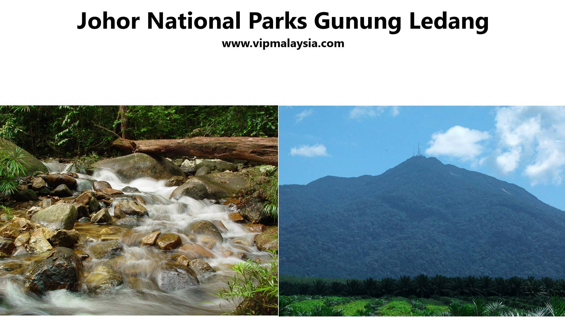
Introduction
Gunung Ledang National Park, established in 2005, is Johor’s crown jewel of eco‑tourism. Rising to 1,276 meters, Gunung Ledang (Mount Ophir) is the highest peak in southern Peninsular Malaysia. The park spans 8,611 hectares of rainforest, serving as a vital water catchment for Johor and Melaka.
Beyond its natural beauty, Gunung Ledang is steeped in folklore. The tale of Puteri Gunung Ledang, a mystical princess who rejected the Sultan of Melaka’s marriage proposal by setting seven impossible demands, adds cultural depth to the mountain’s allure. Today, the park blends Adventure, Biodiversity, and Heritage, making it a must‑visit destination for hikers, families, and cultural explorers.
The Legend of Puteri Gunung Ledang
Gunung Ledang is famously linked to Puteri Gunung Ledang, a legendary princess who, according to historical texts, rejected the marriage proposal of the Sultan of Melaka by setting seven impossible demands, including a golden bridge and silver bridge connecting Melaka to the mountain. This legend has been passed down for generations, making the mountain one of Malaysia’s most mystical landmarks.
A Mountain of Gold
In the 14th century, Chinese sailors called it “Kim Sua” (Gold Mountain), believing the peak contained hidden treasures. British explorers later named it Mount Ophir, alluding to King Solomon’s fabled gold mines.
Trekking & Adventure
How to Reach the Summit
Reaching the summit of Gunung Ledang offers both excitement and challenge, with multiple trails catering to different skill levels. The trek requires stamina and preparation, as hikers navigate steep ascents, dense rainforest, and rocky paths. Whether choosing the more accessible Sagil Trail or the demanding Asahan Trail, the journey rewards adventurers with panoramic views and a sense of accomplishment.
Trails & Scenic Hiking Routes
The mountain features diverse trails that highlight its natural beauty. The Sagil Trail is the most popular and accessible, taking 4–6 hours to reach the peak, while the Asahan Trail offers a longer, steeper climb for seasoned trekkers. Along the way, hikers encounter waterfalls, lush greenery, and scenic viewpoints that make the trek both physically rewarding and visually stunning.
Rich Biodiversity in Johor National Park
Gunung Ledang lies within Johor National Park, a critical water catchment area for Johor and Melaka. The rainforest is home to exotic birds, monkeys, and unique plant species, making it a hotspot for eco-tourism. Its lush tropical jungle not only supports biodiversity but also provides a serene environment for nature lovers seeking an immersive trekking experience.
Preparing for Your Mountain Ascent
To ensure a safe and enjoyable trek, hikers should wear proper boots with strong grip for steep trails, carry sufficient water and snacks to stay hydrated, and begin early in the morning to take advantage of cooler conditions. These simple preparations can make the difference between a challenging struggle and a memorable adventure.
Main Trails
Trail Name
Description
Sagil Trail
Most popular summit route from Johor side. Takes 6–8 hours to ascend (~7–9 km) and 4–5 hours to descend. Features checkpoints (CP1–CP8), rope sections, ladders, and panoramic summit views. Suitable for fit hikers with moderate experience.
Asahan Trail
Challenging summit route from Melaka side. About 12.7 km long with ~1,290 m elevation gain. Includes steep climbs, exposed tree roots, clay paths, and Padang Batu granite slope. Final ascent requires ropes and ladders. Recommended for experienced trekkers.
Lagenda Trail
Extends from Taman Hutan Lagenda entrance to summit. Can be done in a day but often split into two days with camping at Kolam Gajah. Includes ladders on near-vertical granite faces and narrow crevices. Offers sunrise/sunset views from peak.
Gunung Ledang Loop
Strenuous 11 km circuit trail. Begins with hundreds of steps, transitions into rugged rainforest, and includes hazardous rock scrambles, fixed ropes, and bolted ladders. Very muddy terrain.
Bukit Petai Trail
Moderate 5.5 km trail, estimated 2–2.5 hours. Passes through dense jungle with scenic views. Suitable for shorter hikes.
Ampung Jatuh Trail
Moderate 4.2 km trail, estimated 1.5–2 hours. Winds through jungle with steep sections and exposed roots. Ends at a tranquil waterfall.
Puteri Gunung Ledang Waterfalls Trail
Short 2.1 km moderate trail (~1 hour). Leads to waterfalls, ideal for casual hikers and eco-tourism.
Attractions
Summit Trek and Hiking Trails
The summit trek is the park’s main attraction. Climbers face Steep Ascents, Rope Sections, and Rugged Terrain, but are rewarded with panoramic views stretching across Johor and Melaka. The trek typically takes 5–7 hours, depending on fitness levels.
Other trails include shorter jungle walks leading to waterfalls and picnic areas, ideal for families or casual hikers. The trails are well‑marked, with guides available for those seeking a safer, more informative journey.
Waterfalls and Recreational Spots
Gunung Ledang is home to several waterfalls, including Puteri Waterfall, a popular spot for cooling off after hikes. The cascades are surrounded by lush rainforest, offering opportunities for photography and relaxation.
Picnic areas and campsites near the waterfalls make the park suitable for day trips and overnight stays. Families often gather here for weekend outings, enjoying the combination of nature and accessibility.
Puteri Waterfall
Nestled within the lush greenery of Gunung Ledang National Park in Johor, Puteri Waterfall—often referred to as Air Terjun Gunung Ledang—is a destination that blends natural beauty with cultural heritage. Just a short trek from the park’s entrance, this multi-level cascade offers visitors a refreshing escape from city life, while immersing them in the folklore of Malaysia’s legendary princess.
The journey to the waterfall begins with a 30-minute walk along a well-maintained trail shaded by towering trees. The sound of rushing water grows louder as you approach, until the falls reveal themselves in a series of cascades tumbling into clear pools. These pools are popular for swimming, while the surrounding areas provide shaded spots perfect for picnics and relaxation.
Beyond its natural charm, Puteri Waterfall carries a mystical aura tied to Malay folklore. The site is named after the Princess of Gunung Ledang, a figure immortalized in stories of Sultan Mansur Shah of Malacca, who sought her hand in marriage. Her legendary conditions for marriage—seen as impossible to fulfill—have become part of Malaysia’s cultural tapestry, adding depth to the visitor experience.
For those seeking adventure, the waterfall serves as a gateway to more challenging treks up Gunung Ledang itself, a climb that can take six to eight hours and rewards hikers with panoramic views of Johor and Melaka. Yet, even without scaling the mountain, Puteri Waterfall offers plenty: birdwatching opportunities, photography spots, and a serene environment to reconnect with nature.
Facilities such as restrooms, showers, and designated picnic areas make the site accessible to families and casual travelers. However, visitors are advised to wear proper footwear, as trails can be slippery after rain, and to bring essentials like insect repellent and drinking water.
Puteri Waterfall, also known as Air Terjun Gunung Ledang, is a multi-level cascade located in Johor’s Gunung Ledang National Park. It is famous for its lush tropical surroundings, picnic spots, and the folklore of the Princess of Gunung Ledang.
Visitor Facilities
The park is equipped with modern facilities to enhance visitor experiences:
Visitor Complex with park office, gallery, mini library, and audio‑visual room.
Dewan Lagenda Hall for cultural events and group activities.
Cafeteria and Cooking Areas (meals available with prior arrangement).
Obstacle Course and Jungle Huts for team‑building.
Surau, Toilets, and Showers for convenience.
Wildlife and Biodiversity
Gunung Ledang’s rainforest supports diverse flora and fauna:
Birds: Hornbills, Eagles, and Kingfishers.
Mammals: Macaques, Civets, and Squirrels.
Plants: Pitcher Plants, Orchids, Ferns, and Dipterocarp Trees.
Macaques are monkeys of the genus Macaca, found across Asia and North Africa. They live in social troops with complex hierarchies and are highly adaptable to human environments. Their diet includes fruits, seeds, leaves, and occasionally insects or small animals.
Civets are small nocturnal mammals of the family Viverridae, native to Asia and Africa. They are known for their musky scent and play a role in producing kopi luwak coffee. Civets are omnivorous, feeding on fruits, insects, and small animals.
Squirrels are rodents of the family Sciuridae, found worldwide in forests, parks, and urban areas. They are recognized for their bushy tails and agile climbing abilities. Squirrels store seeds and nuts, which contributes to forest regeneration.
The park’s biodiversity reflects its role as a Critical Conservation Area, protecting species while offering educational opportunities for visitors.
Cultural Significance and Festivals
The legend of Puteri Gunung Ledang remains central to the park’s identity. Cultural festivals and storytelling events occasionally highlight this folklore, connecting visitors to Malaysia’s heritage.
Local communities in nearby towns sometimes organize Traditional Performances and Food Fairs, especially during school holidays, making a visit to Gunung Ledang both a natural and cultural experience.
Nearby Towns and Access
Tangkak: The closest town, offering accommodations, food stalls, and transport services.
Melaka City: About an hour away, providing a wider range of hotels, cultural attractions, and dining options.
Johor Bahru: Approximately 2.5 hours by car, making the park accessible for weekend trips.
Tangkak is a town in northern Johor, close to the border with Melaka. It is well known as Malaysia’s “Textile Town” because of its thriving fabric and garment trade. The town is also a gateway to Gunung Ledang (Mount Ophir), a popular hiking spot tied to Malay legends, and is famous for dishes like Tangkak Beef Noodles.
Melaka is Malaysia’s “Historic State,” located on the west coast about two hours south of Kuala Lumpur. It has a rich past shaped by Malay, Portuguese, Dutch, and British influences, and its city center is a UNESCO World Heritage Site. Visitors are drawn to landmarks such as A Famosa Fort, Stadthuys, and Jonker Street, as well as its renowned Nyonya cuisine and desserts like cendol.
Conclusion
Gunung Ledang National Park is a destination where Nature, Adventure, and Legend Converge. From the Challenging Summit Trek to the Serene Waterfalls, and from the Modern Visitor Facilities to the Rich Cultural Folklore, the park offers experiences for every type of traveler.
Plan your visit today — Gunung Ledang National Park awaits with unforgettable adventures that showcase Malaysia’s Mountain of Legends.
Summary
Attraction: Gunung Ledang
Location: #Johor
Attraction Type: #Mount
Source: johornationalparks.gov.my
Must‑Visit Highlights:
Summit Trek: A challenging climb with breathtaking views.
Puteri Waterfall: A scenic cascade perfect for relaxation.
Visitor Complex: Cultural exhibits and educational facilities.
Legendary Folklore: The story of Puteri Gunung Ledang adds depth to the experience.
Nearby Towns: Tangkak and Melaka offer cultural and culinary extensions to the trip.
Quick Info
Attribute
Details
Name
Gunung Ledang (Mount Ophir)
Location
Johor National Park, Tangkak District, Johor, Malaysia
GPS Position
2°20’27.6″N, 102°37’03.0″E (≈ 2.3409° N, 102.6175° E)
State
Johor
Facility Type
National Park, Hiking Trails, Camping Grounds
Main Attractions
Mountain Summit (1,276 m), Puteri Falls, Legends of Puteri Gunung Ledang, Wildlife Exploration
Nearby Landmarks
Tangkak Town, Segamat, Melaka Historical Sites
Accessibility
Reachable via trailheads in Sagil (Johor) & Asahan (Melaka)
Best Time to Visit
Dry season (March–September) for clearer skies and safer trekking
Entry Fees
RM 5–16 (Malaysians), RM 10–26 (foreigners), summit permit RM 13–20, camping RM 3–5 per night
Johor National Parks Office: Office +60 6 963 1030, Mobile +60 19 777 2057
Visitor Information
Tsonz, Singapore – ★★★★☆ “I started the Sagil Trail at 8 AM after registering and declaring my items at the park office. The hike was steep with steps, rope climbs, and multiple ladders. We reached the summit by 12:50 PM, just before the 2 PM cut-off. The climb was tough but manageable with training. Sadly, clouds blocked the view, though guides said clear days offer spectacular sights over Melaka. Finished by 4 PM. Bring proper boots and don’t overpack — there are water points along the way.”
Nor B., Kluang – ★★★☆☆ “I’ve hiked Gunung Ledang twice, once via Sagil and once via Asahan. The Sagil route is more organized with checkpoints, but crowded on weekends. The Asahan trail is steeper and muddier, with exposed tree roots and clay paths. The Padang Batu granite slope was stunning but very challenging. Facilities at the base are basic, and permits can feel bureaucratic. Still, the biodiversity and the legend of Puteri Gunung Ledang make it special.”
Johan K., Netherlands – ★★★★☆ “As a backpacker, I found Gunung Ledang both rewarding and frustrating. The summit trek felt like an obstacle course with ropes and ladders, not a casual hike. Camping was cheap, and trails were well-marked, so I could go without a guide. But bureaucracy at the entrance and noisy weekend groups took away from the wilderness vibe. Compared to Taman Negara, it feels more managed, but still worth it for the challenge and views.”
Frequently Asked Questions (FAQs)
How the name Gunung Ledang is derived from?
The name “Gunung Ledang” is likely to have been coined during the reign of the Majapahit empire. In Old Javanese, “Ledang” may be translated as “high”, “faraway”, or “showy”.
What are the old fairy tales and legendary stories about Gunung Ledang?
About the seven impossible demands to Sultan of Melaka and gold treasure like King Solomon. No wonder it was called as Kim Sua or gold mountain.
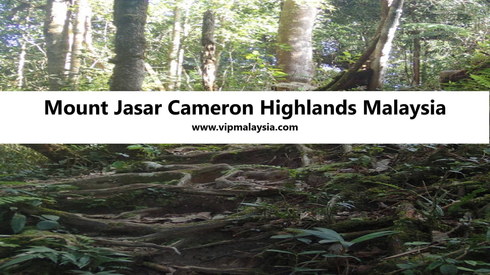
Located in the heart of Cameron Highlands, Mount Jasar offers one of the most picturesque hiking experiences in Malaysia. Whether you’re an avid trekker, a nature enthusiast, or looking for a moderate adventure, this hike provides breathtaking views and rich biodiversity, making it a must-visit spot.
Introduction
Mount Jasar (also called Gunung Jasar) is one of the most accessible peaks in the Cameron Highlands, located just outside the town of Tanah Rata in Pahang, Malaysia. The mountain offers a moderate-level trek that typically takes 2–4 hours round trip, winding through dense jungle terrain with occasional steep inclines.
At the summit, hikers are rewarded with panoramic views of Ringlet town, Bharat Tea Plantation, and surrounding highland ranges. A large electric transmission tower near the peak serves as a recognizable landmark. The trail is most commonly accessed via Trail 10 near Carnation Park or through Tan’s Camellia Garden, both within walking distance of Tanah Rata.
Ringlet (1,127–1,135 meters above sea level) is the southernmost town in Cameron Highlands, Pahang, Malaysia, often called the gateway to the highlands when driving up from Tapah along Federal Route 59. It is known for its tea plantations, vegetable farms, and cool mountain climate, serving as a hub for agriculture and a quieter alternative to tourist-heavy towns like Tanah Rata and Brinchang.
Mount Jasar is also culturally significant, as trails nearby connect to the Orang Asli village of Sg Ruil, offering visitors a chance to experience indigenous traditions. Its biodiversity includes orchids, mosses, butterflies, and bird species, making it a rich ecological site.
Mount Jasar is a scenic mountain in Cameron Highlands, Malaysia, known for its moderate hiking trails, lush jungle terrain, and panoramic views of Ringlet town and Bharat Tea Plantation. It stands at an elevation of about 1,655–1,696 meters and is easily accessible from Tanah Rata, making it a popular trek for both casual hikers and nature enthusiasts.
History
Mount Jasar’s trails were originally used by locals and settlers navigating the highlands. During the British colonial era, Cameron Highlands became a retreat for cooler climates, and tea plantations flourished. Mount Jasar’s vantage points offered surveyors and planters sweeping views of the valleys below. Over time, the trail evolved into a recreational path, attracting hikers who wanted to experience the highland ecosystem. Today, it remains a blend of heritage and nature, with remnants of old pathways and modern signboards guiding trekkers.
Highlights
Trailhead Location
Mount Jasar’s main trailhead begins at Tan’s Camellia Garden or via Trail 10 near Carnation Park. These entry points are well-marked, making navigation straightforward. The garden itself is a charming attraction, filled with colorful blooms that set the tone for the trek.
Trail Entry
The Camellia Garden entrance feels like stepping into a living postcard. Visitors pass through manicured flower beds before entering dense jungle terrain. Trail 10, on the other hand, offers a more rustic start, with a narrow path leading directly into the forest canopy.
Trekking Experience
The trek is moderate, lasting about 2–4 hours round trip depending on pace. Paths wind through dense jungle, with gradual inclines punctuated by occasional steep climbs. Along the way, hikers encounter vibrant flora such as red ginger plants, moss-covered trees, and delicate orchids.
Jungle Terrain And Flora
The forest floor is alive with ferns, lichen, and fungi. Butterflies flutter across sunlit clearings, while bird calls echo through the canopy. This biodiversity makes Mount Jasar not just a hike, but an ecological exploration.
Peak View And Scenic Highlights
At the summit, hikers are rewarded with panoramic views of Ringlet town, the Bharat Tea Plantation, and distant mountain ranges. A large electric transmission tower near the peak serves as a landmark and photo spot.
Bharat Tea Plantation, also known as Cameron Valley Tea Estate, is one of the largest and most accessible tea plantations in Cameron Highlands, Malaysia. Established in 1933 by the Bharat Group, it is the second-largest tea producer in the country and is famous for its Cameron Valley Tea brand.
Highland Perspectives
From this vantage point, the rolling tea fields resemble a green quilt stitched across the valley. Mist often drifts through the ridges, creating a mystical atmosphere. Sunrise hikes are particularly magical, with golden light illuminating the plantations below.
Trekking And Adventure
Gunung Perdah Extension
For those seeking more adventure, the trail extends to Gunung Perdah, a neighboring peak. This section is less frequented, offering solitude and deeper immersion into the jungle. Mist often blankets the path, adding an ethereal quality to the trek.
Misty Jungle Experience
The Gunung Perdah trail feels untouched, with narrower paths and denser vegetation. Hikers often describe the silence as profound, broken only by the rustle of leaves and distant bird calls.
Orang Asli Village (Sg Ruil)
Nearby lies the Sg Ruil Orang Asli village, home to Malaysia’s indigenous people. Visitors can explore traditional bamboo houses, learn about handicrafts, and experience authentic cultural practices.
Cultural Encounters
Interacting with the Orang Asli offers insight into their sustainable lifestyle. Many villagers share stories of living in harmony with the forest, using plants for medicine and rituals. This cultural dimension enriches the Mount Jasar trek beyond nature.
Must‑Visit Highlights
Tanah Rata Town
Tanah Rata serves as the gateway to Mount Jasar. The town offers cozy guesthouses, local eateries, and colonial‑era buildings. It’s also a hub for buses and taxis, making logistics simple for visitors.
Visitor Facilities
Tanah Rata provides essentials like ATMs, pharmacies, and gear shops. After the trek, hikers often relax at local cafés, sampling Cameron Highlands’ famous strawberry desserts.
Bharat Tea Plantation
Visible from Mount Jasar’s summit, the Bharat Tea Plantation is a must‑visit. Sprawling tea fields stretch across rolling hills, and visitors can tour the estate, sip freshly brewed tea, and enjoy scenic viewpoints.
A tea plantation in Cameron Highlands refers to large cultivated estates where tea is grown, processed, and packaged, taking advantage of the region’s cool climate and fertile highland soil. These plantations, such as BOH, Bharat, and Cameron Valley, are iconic attractions offering scenic landscapes, visitor centers, and insights into Malaysia’s tea heritage.
The plantation café offers panoramic views while serving signature Cameron Valley teas. Learning about tea processing adds depth to the visit, connecting the landscape to its economic and cultural significance.
Cameron Valley refers to the tea estates owned by the Bharat Group of Companies, located along the main road between Ringlet and Tanah Rata in Cameron Highlands. Established in 1933, the plantation covers about 1,600 acres and is Malaysia’s second‑largest tea producer, marketing its products under the brand Cameron Valley Tea.
Visitors can enjoy freshly brewed tea, scones, and cakes at the plantation’s tea houses, explore short walking trails through the tea fields, and learn about tea cultivation through audio‑visual presentations. The estate is recognized for its picturesque landscapes, cultural heritage, and accessibility, making it one of the most popular attractions in Cameron Highlands.
Wildlife Encounters
Mount Jasar’s biodiversity is remarkable. Hikers may spot butterflies, hornbills, and small mammals. The flora includes orchids, mosses, and towering hardwood trees.
Species Highlights
Butterflies such as the Rajah Brooke’s Birdwing add splashes of color to the trail. Birdwatchers often record sightings of bulbuls and drongos. The forest’s layered vegetation supports a thriving ecosystem.
Rajah Brooke’s Birdwing (Trogonoptera brookiana), commonly called the Rajah Brooke butterfly, is a striking birdwing species native to the rainforests of the Thai‑Malay Peninsula, Borneo, and Sumatra. It is Malaysia’s national butterfly, named in 1855 by Alfred Russel Wallace after James Brooke, the Rajah of Sarawak.
Hiking Tips And Visitor Essentials
Best Time To Visit
The dry season from March to September offers the safest and most scenic conditions. Trails are less muddy, and visibility is excellent. Early morning hikes provide cooler temperatures and breathtaking sunrise views.
Seasonal Considerations
Afternoon rains are common outside the dry season, making trails slippery. Planning hikes in the morning ensures a safer and more enjoyable experience.
What To Pack
Proper gear enhances comfort and safety. Essentials include sturdy hiking shoes, lightweight clothing, water, snacks, and a camera. Bug repellent is crucial, as mosquitoes thrive in jungle environments.
Eco‑Friendly Gear
Visitors are encouraged to bring reusable bottles and avoid single‑use plastics. Respecting the environment ensures Mount Jasar remains pristine for future generations.
Conclusion
Mount Jasar offers a breathtaking highland adventure, blending scenic landscapes, rich biodiversity, and accessible trekking routes in Malaysia’s renowned mountain retreat. Whether you’re a casual hiker or an experienced trekker, this destination promises stunning views and unforgettable experiences.
Plan your adventure today—explore the beauty of Mount Jasar, Cameron Highlands!
Visitor Reviews
Tumiran Yusoff, Kuala Lumpur – 5 Stars “Mount Jasar was the highlight of my Cameron Highlands trip. The trail was challenging but manageable, and the views of the tea plantations were breathtaking. I loved the cultural stop at the Orang Asli village—it made the hike even more meaningful.”
Sam Lim, Penang – 4 Stars “The trek took us about three hours, with some steep sections. The jungle was lush and full of butterflies. The only downside was the muddy trail after rain, but overall it was a rewarding experience.”
Sofia Badrulhisyam, Johor Bahru – 5 Stars “An amazing hike! The sunrise from the summit was magical. The trail was well-marked, and we felt safe throughout. Visiting the Bharat Tea Plantation afterward was the perfect way to end the day.”
Marcus Lee, Singapore – 4 Stars “Mount Jasar offered a great balance of adventure and accessibility. The electric tower near the peak was a unique landmark. I’d recommend starting early to avoid afternoon rain.”
Summary
Attraction: Mount Jasar
Location: #Pahang #CameronHighlands
Attraction Type: #Mount
Source: asme.wordpress.com
Why Hike:
Moderate-level trek – Suitable for anyone with a basic fitness level
Nestled in the heart of Cameron Highlands, Mount Irau offers a captivating hiking experience, taking adventurers through a fairy-tale-like mossy forest, cool mountain breezes, and misty clouds. Standing at 2,110 meters (6,922 feet), this highland gem is among Malaysia’s most breathtaking trekking destinations.
Introduction
Mount Irau stands tall at 2,110 meters above sea level, making it one of the most captivating peaks in Malaysia’s Cameron Highlands. Known as the “mossy forest mountain,” it offers hikers a surreal journey through landscapes blanketed in velvety moss, twisted roots, and misty air. The mountain is a paradise for nature lovers, adventure seekers, and photographers alike. Its unique ecosystem, cool temperatures, and panoramic summit views make it a must-visit destination for both domestic and international travelers.
History
Mount Irau has long been part of the cultural and ecological heritage of the Cameron Highlands. Historically, the indigenous Orang Asli communities revered the mountain as a sacred site, believing its moss-covered forest to be home to spirits and natural guardians. During the colonial era, British explorers and botanists documented the area’s rare flora, contributing to its reputation as a biodiversity hotspot. The mountain’s mossy forest is now recognized as one of Malaysia’s most unique ecological treasures. Conservation efforts continue to protect its fragile ecosystem from over-tourism and environmental degradation.
Highlights
Mossy Forest Magic
The mossy forest is the crown jewel of Mount Irau. Visitors are greeted by ancient trees draped in moss, mist drifting through the canopy, and roots forming natural sculptures. Walking through this forest feels like stepping into a fairytale world. The biodiversity here includes orchids, ferns, pitcher plants, and rare wildlife species such as mountain shrews and highland birds.
Visitor Facilities
Facilities near the Mossy Forest entrance include parking areas, rest stops, and guided tour services. Local operators provide 4×4 transfers to the trailhead, ensuring accessibility for all visitors. Eco-tourism initiatives emphasize sustainable practices, encouraging hikers to minimize waste and respect the fragile environment.
5 Best Mossy Forest Mountains in Malaysia
Mountain & Location
Highlights
Mount Brinchang, Cameron Highlands (Pahang)
Famous Mossy Forest boardwalk, 2,032m peak, panoramic views, orchids, ferns, and pitcher plants.
Mount Irau, Cameron Highlands (Pahang)
Known as the “mossy forest mountain,” surreal misty trails, twisted roots, and panoramic summit at 2,110m.
Mount Kinabalu, Sabah
UNESCO World Heritage Site, mossy forest zones between 2,000–3,000m, rare orchids, pitcher plants, and endemic species.
Gunung Angsi, Negeri Sembilan
Less crowded mossy trails, rich biodiversity, and cooler climate compared to lowland forests.
Gunung Ledang, Johor
Legendary mountain with mossy forest sections, mystical atmosphere, and cultural folklore tied to local history.
Gunung Batu Brinchang
Gunung Batu Brinchang, located nearby, offers a scenic warm-up trek before tackling Mount Irau. Standing at 2,031 meters, it is accessible via road and features a watchtower with panoramic views of the Cameron Highlands. This trek is ideal for acclimatizing to the altitude and enjoying breathtaking vistas.
Cultural Festivals Nearby
The Cameron Highlands host annual festivals celebrating tea, strawberries, and local culture. Visitors often combine their trek with these events, experiencing traditional dances, food fairs, and handicraft exhibitions. These festivals enrich the hiking journey with cultural immersion.
Jungle Walk 14
For those seeking extended adventures, Jungle Walk 14 provides an alternative trail through dense forest canopies. Known for its biodiversity, this trail showcases unique plant species and offers opportunities for birdwatching. It is a favorite among ecologists and nature photographers.
Wildlife Species
Wildlife spotted along Jungle Walk 14 includes silvered leaf monkeys, hornbills, and rare butterflies. The trail’s dense vegetation supports a thriving ecosystem, making it a living classroom for biodiversity enthusiasts. Encounters with wildlife add excitement to the trekking experience.
Attractions
Panoramic Summit Views
Reaching the summit of Mount Irau is a rewarding achievement. The peak offers panoramic views of the Cameron Highlands, with rolling hills, tea plantations, and distant peaks visible on clear days. The summit is a perfect spot for photography and reflection.
Best Time To Visit
The best time to hike Mount Irau is during the dry season, typically from March to September. Cooler temperatures and clearer skies enhance the trekking experience. Avoiding the monsoon season ensures safer and more enjoyable hikes.
Malaysia’s monsoon season refers to two distinct wind and rainfall regimes that shape the country’s climate: the Northeast Monsoon (November–March) and the Southwest Monsoon (May–September). The Northeast Monsoon is wetter and often causes flooding along the east coast, while the Southwest Monsoon is relatively drier.
Eco-Tourism And Conservation
Mount Irau’s mossy forest is fragile, requiring careful conservation. Local authorities and NGOs promote eco-tourism practices, including limiting visitor numbers and maintaining trails. Hikers are encouraged to respect nature and contribute to conservation efforts.
Hiker Conservation Guidelines
Do
Don’t
Carry Reusable Bottles – Reduce plastic waste by bringing refillable water containers.
Leave Trash Behind – Never litter; pack out all waste to protect fragile ecosystems.
Stick To Designated Trails – Prevent erosion and protect mossy forest vegetation.
Trample Off-Trail Areas – Avoid damaging moss beds and rare plants by wandering off paths.
Use Eco-Friendly Gear – Choose biodegradable soaps and sustainable hiking equipment.
Use Harsh Chemicals – Avoid insect repellents or detergents that harm soil and water quality.
Respect Wildlife – Observe animals quietly without disturbing their natural behavior.
Feed Wild Animals – Feeding disrupts diets and can make animals dependent on humans.
Join Guided Tours – Local guides share knowledge and ensure sustainable practices.
Ignore Safety Advice – Skipping instructions can endanger both hikers and the environment.
Support Local Communities – Buy local produce or crafts to encourage eco-tourism.
Exploit Resources – Avoid damaging plants or taking souvenirs from the forest.
Practice Leave No Trace – Ensure the forest remains pristine for future visitors.
Start Fires – Open flames can devastate mossy forests and wildlife habitats.
Check Weather Forecasts – Plan hikes during safe conditions to minimize trail damage.
Hike In Heavy Rain – Wet conditions increase erosion and trail degradation.
Participate In Clean-Up Drives – Help maintain trails and reduce human impact.
Ignore Conservation Rules – Disregarding park regulations harms preservation efforts.
Educate Fellow Hikers – Share eco-friendly practices to build awareness.
Disturb Cultural Sites – Avoid disrespecting indigenous heritage or sacred areas.
Sustainable Practices
Visitors are advised to carry reusable water bottles, avoid littering, and stick to designated paths. Guided tours often include educational sessions on the importance of preserving the mossy forest. Sustainability ensures that future generations can enjoy Mount Irau’s beauty.
Cameron Highlands Strawberry Farms
After a challenging trek, visitors can unwind at nearby strawberry farms. These farms allow guests to pick fresh strawberries, enjoy desserts, and purchase local produce. The farms are a delightful way to experience the agricultural charm of the Cameron Highlands.
Cameron Highlands strawberries are typically medium-sized, bright red, and glossy, cultivated in cool highland climates that give them a sweeter taste and firmer texture compared to lowland varieties. Their appearance is enhanced by greenhouse and hydroponic farming methods, producing uniform rows of vibrant berries ideal for picking and photography.
Tanah Rata and Brinchang are the closest towns, offering accommodations, restaurants, and transport services. Tanah Rata is known for its colonial-style guesthouses, while Brinchang features bustling night markets. Both towns serve as convenient bases for exploring Mount Irau and surrounding attractions.
Trekking And Adventure
Starting Point And Trail Overview
The trek begins at the Mossy Forest entrance near Cameron Square. Free parking is available, and most hikers opt for a 4×4 transfer to the trailhead. The trail to the summit takes approximately 3–4 hours, depending on pace and weather conditions. The journey is as rewarding as the destination, with every step revealing new natural wonders.
Cameron Square is the first and only shopping complex in Cameron Highlands, strategically located at Kea Farm next to the Copthorne Hotel. It features a three-level commercial center with over 100 retail outlets and 342 parking spaces, making it a central hub for visitors and locals alike. Restaurants, cafés, pharmacies, boutiques, and entertainment outlets operate within its 160,000 sq ft premises.
Trail Difficulty
The trail is moderately challenging, requiring stamina and proper footwear. Slippery, muddy paths and steep ascents test hikers’ endurance. Preparation and caution are essential for a safe and enjoyable trek.
Mossy Forest Trek
The mossy forest trail is the highlight of the Mount Irau hike. Tree roots form natural staircases, while moss blankets every surface. Mist often drifts through the forest, creating an ethereal atmosphere. This section of the trek is both challenging and mesmerizing.
Terrain Challenges
Hikers must navigate muddy paths, crawl through narrow tree openings, and balance on root formations. These natural obstacles add adventure to the trek, making it a thrilling experience. The terrain demands resilience but rewards hikers with unforgettable memories.
Conclusion
Mount Irau offers a mystical hiking adventure, blending moss-covered landscapes, challenging trails, and rewarding summit views for nature lovers and thrill-seekers alike. Whether you’re a seasoned hiker or a first-time explorer, this highland trek promises an unforgettable journey through one of Malaysia’s most unique forests.
Plan your adventure today—immerse yourself in the enchantment of Mount Irau!
Summary
Attraction: Mount Irau
Location: #Pahang #CameronHighlands
Attraction Type: #Mount
Source: pokokkelapa.wordpress.com
Why Hike:
Explore Malaysia’s famous mossy forest – A rare natural wonder with dreamlike landscapes
Enjoy cool mountain temperatures – Escape the heat and immerse in fresh, crisp air
Perfect for nature lovers & adventure seekers – Witness ancient trees, twisted roots & vibrant greenery
Rewarding summit views – Marvel at panoramic highland scenery once you reach the peak
Quick Info
Attribute
Details
Name
Mount Irau (Gunung Irau)
Location
Cameron Highlands, Pahang, Malaysia
GPS Position
4.4889° N, 101.3890° E
State
Pahang
Facility Type
Highland Hiking & Nature Trek
Main Attractions
Mossy Forest, Jungle Walk 14, Stunning Highland Views
Nearby Landmarks
Gunung Batu Brinchang, Cameron Strawberry Farms
Accessibility
Starting point at Mossy Forest with 4×4 shuttle
Best Time to Visit
Morning for cool temperatures & best visibility
Hiking Duration
3-4 hours to reach summit
Recommended Gear
Hiking boots, rain protection, energy snacks
Entry Fees
May vary based on guided tours
Contact
Phone: +6019-451 8380
Visitor Reviews
Angeline Tan, Kuala Lumpur – ★★★★★ “The mossy forest was unlike anything I’ve ever seen. The mist and moss created a magical atmosphere, and the summit views were breathtaking. Highly recommend proper hiking shoes!”
Mamu Iskandar, Penang – ★★★★☆ “The trek was challenging but rewarding. Crawling through tree roots was tough, but it added to the adventure. The nearby strawberry farms were a sweet bonus after the hike.”
Jennifer Williams, London – ★★★★★ “Mount Irau was the highlight of my trip to Malaysia. The biodiversity was incredible, and the guided tour was very informative. The cool climate made the hike comfortable.”
Dang Anum, Melaka – ★★★★☆ “The trail was muddy and slippery, but that’s part of the charm. The mossy forest felt like stepping into another world. I would love to return during the dry season.”
Steve Melvin, California – ★★★★★ “Absolutely stunning! The mossy forest is a photographer’s dream. The cultural festivals in Cameron Highlands added so much to the experience. Truly unforgettable.”
Frequently Asked Questions (FAQs)
Berapakah ketinggian Gunung Irau di Cameron Highlands?
Gunung yang sangat popular di Pahang, iaitu Mount Irau mempunyai ketinggian 2,032 meter. Untuk mencapai puncaknya pula adalah 2,110 meter.
What are the best tips for hiking Mount Irau in Cameron Highlands?
Tips for hiking Mount Irau:
Walk with the weather in mind. If you want to avoid the mud go during the dry season. Otherwise pack some layers and rain resistant outerwear.
Pick your shoes wisely. The acidity of the peat bog eats away shoe glue so make sure you have good walking or hiking shoes on. Converse were common on the trail but a mistake and donning your favourite sneakers are not a good idea either unlike you fancy having them seasoned. Locals recommend adidas kampung which you can get from any descent hardware store for between RM8 and Rm12 a pair.
Report in and stay in touch. Hikers are required to gain a permit from the forestry department before entering but few do. You are also recommended to report your plans to the police before your trip. Accidents happen, so keep your phone charged up and data off to prolong battery life. It was only when Hafiza, Hakim and I returned to KL that we found out that one KL Hiker had injured her knee and was carried out by the fire brigade at midnight.
Apakah pakej yang ditawarkan Gunung Irau, Cameron Highlands?
Mossy Forest Boardwalk, 4×4 Transfer & Tiket masuk.
Mount Irau Cameron Highlands Jadual Pakej A:
Parking Kereta di Ladang Teh Sg Palas (lokasi akan diberi)
Naik 4×4 dan menuju ke Wakaf Mossy Forest (20 minit)
Masuk Mossy Forest (30 minit)
Pulang ke parking kereta di Ladang Teh (20 minit)
Total perjalanan 1 jam 20 minit(+-)
Guide SOS, 4×4 Transfer, Permit Mendaki, Tiket Mossy Forest, Lunch Pack (Nasi Ayam Berempah), Radio Comm, First Aid Kit Standby, Police Report & Management Fees.
Mount Irau Cameron Highlands Jadual Pakej B:
0700 – Berkumpul di Nova Square, breakfast, parking kereta, pemeriksaan suhu & pendaftaran.
0730 – Taklimat dari Guide SOS, menaiki 4×4 ke Wakaf Irau.
0830 – Selepas senaman ringan, kita mulakan pendakian.
1130 – Dijangka semua peserta tiba di Puncak Mini Irau. Bergambar kenangan & makan tengahari.
1230 – Mula turun ke wakaf.
1430 – Dijangka tiba di wakaf, naik 4×4 turun ke Nova Square.
1530 – Dijangka semua selamat tiba di parkir, aktiviti tamat.
Standing at 2,032 meters above sea level, Mount Brinchang is the highest peak in Cameron Highlands accessible by road, offering breathtaking panoramic views, untouched mossy forests, and a rich biodiversity of unique plants and wildlife. Whether you’re a nature lover, an adventure enthusiast, or a traveler seeking stunning landscapes, this mountain promises an unforgettable highland experience.
Introduction
Standing tall at 2,032 meters above sea level, Mount Brinchang is a crown jewel of Cameron Highlands in Malaysia. Known as the highest peak accessible by road in Peninsular Malaysia, it combines natural beauty with accessibility, making it a favorite among travelers. The mountain is home to the mystical Mossy Forest, a 190-million-year-old ecosystem filled with rare orchids, carnivorous plants, and moss-covered trees. Visitors can enjoy scenic drives, jungle treks, and breathtaking views from the summit’s observation tower. Beyond its natural wonders, Mount Brinchang connects travelers to nearby towns, cultural festivals, and highland traditions that enrich the experience.
History
Mount Brinchang’s history is deeply tied to the development of Cameron Highlands as a colonial hill station during the British era. The mountain was once a strategic lookout point, offering commanding views of the surrounding valleys and tea plantations. Over time, it became a hub for ecological research due to its unique biodiversity. The Mossy Forest, in particular, has fascinated botanists and conservationists for decades, with its ancient plant species and rare wildlife. Today, Mount Brinchang stands as both a natural heritage site and a popular tourist destination, balancing conservation with tourism.
Highlights
Mossy Forest Discovery
The Mossy Forest is one of the most enchanting attractions on Mount Brinchang. This ancient forest, estimated to be over 190 million years old, is covered in thick moss, creating an otherworldly atmosphere. Visitors can explore wooden boardwalks that wind through the forest, offering safe access to its fragile ecosystem. The forest is home to unique species such as pitcher plants, wild orchids, and medicinal herbs like citronella. Its misty ambiance makes it a favorite for photographers and nature lovers.
The Mossy Forest in Cameron Highlands is a high-altitude cloud forest known for its misty atmosphere, moss-covered trees, and unique biodiversity. Visitors can enjoy guided walks, photography, birdwatching, and exploring rare plants and wildlife in this enchanting ecosystem. It typically takes about 3 hours to reach the peak of Gunung Irau’s Mossy Forest in Cameron Highlands, with the return journey taking around 4 hours. For shorter hikes within the Mossy Forest boardwalk area, visitors usually spend about 1 hour.
Unique Flora And Fauna
The Mossy Forest shelters rare plants like the Nepenthes pitcher plant, which traps insects, and delicate orchids that thrive in the cool climate. Wildlife includes mountain squirrels, exotic birds like the black-throated sunbird, and even rare reptiles. The biodiversity here is a living museum of evolution, offering insights into Malaysia’s ecological richness.
Observation Tower And Panoramic Views
At the summit of Mount Brinchang, the observation tower provides a 360-degree view of Cameron Highlands and the Titiwangsa Mountain Range. On clear days, visitors can see as far as Ipoh and the surrounding valleys. The tower is especially popular at sunrise, when mist blankets the highlands, creating a mystical landscape. It is also a hotspot for photography, with sweeping views of tea plantations, villages, and rolling hills.
The Observation Tower is located at the Mossy Forest entrance near Gunung Brinchang (2,032 meters above sea level). It is designed to give visitors a bird’s‑eye view of the Cameron Highlands landscape, including rolling tea plantations, valleys, and the mystical cloud forest.
Sunrise And Sunset Experiences
Watching the sunrise from Mount Brinchang is a magical experience. The sky shifts from deep blue to golden hues, illuminating the misty valleys below. Sunset offers equally stunning views, with the highlands bathed in warm light. Both times of day provide unforgettable moments for travelers seeking serenity and beauty.
Orang Asli
Visitors can also experience traditional Orang Asli culture, with handicrafts and performances that reflect indigenous heritage.
The Orang Asli are Malaysia’s indigenous people, and in Cameron Highlands they live in villages near the Mossy Forest. Their presence adds a cultural dimension to the natural attraction, as visitors can learn about traditional lifestyles, crafts, and the community’s deep connection to the forest ecosystem.
The Orang Asli tribes near the Mossy Forest in Cameron Highlands are primarily from the Semai group, one of the largest Orang Asli communities in Malaysia. Visitors can engage in cultural tours, watch blowpipe demonstrations, explore bamboo huts, and learn about traditional forest knowledge such as medicinal plants and sustainable living practices.
Village Tours
Exploring the Orang Asli villages near Mossy Forest offers a glimpse into traditional living spaces built from bamboo and natural materials. Visitors can walk through these huts, observe daily routines, and appreciate the harmony between the community and their environment.
These tours highlight the resilience and ingenuity of the Orang Asli, who have adapted their homes to the forest’s climate and resources. It’s a chance to understand how architecture reflects cultural identity and sustainable living practices.
Blowpipe Demonstrations
The blowpipe is a fascinating hunting tool used by the Orang Asli, and demonstrations allow visitors to see its precision in action. Guides often explain how darts are crafted and used to hunt small animals in the dense forest.
Participating in or observing these demonstrations provides insight into survival skills passed down through generations. It’s both an educational and interactive way to connect with indigenous traditions.
Medicinal plants
The Orang Asli have deep knowledge of forest herbs and plants, many of which are used for healing and wellness. Guided walks often reveal how leaves, roots, and barks are prepared for remedies.
Learning about these practices emphasizes the importance of biodiversity and the wisdom embedded in indigenous medicine. It also shows how cultural traditions preserve ecological balance.
Medicinal plants in the Mossy Forest of Cameron Highlands include species such as orchids, pitcher plants, ferns, and herbal shrubs traditionally used by locals and Orang Asli communities for remedies. These plants thrive in the misty, high-altitude environment and are often highlighted during guided eco-tours.
Handicrafts
Handmade baskets, tools, and souvenirs crafted by the Orang Asli reflect both artistry and utility. Each item is woven or carved with techniques that have been refined over centuries.
Purchasing these handicrafts not only supports the community but also allows visitors to take home a piece of cultural heritage. It’s a meaningful way to contribute to local livelihoods.
Storytelling
Oral traditions are central to Orang Asli culture, with myths and legends tied closely to the forest. Storytelling sessions often reveal moral lessons, ancestral wisdom, and connections to nature.
Listening to these tales fosters respect for indigenous identity and highlights the role of narrative in preserving cultural memory. It’s an immersive experience that bridges past and present.
Examples of Orang Asli Myths & Beliefs
Forest spirits: The Orang Asli believe the Mossy Forest is inhabited by spirits that guard the land. Disturbing the forest without respect can bring misfortune.
Animism: Every tree, rock, and stream is thought to have a soul or life force. This belief shapes taboos against cutting certain trees or harming animals unnecessarily.
Sacred sites: Certain areas of the forest are considered sacred, where rituals or offerings are made to maintain balance with nature.
Myths of ancestors: Oral traditions recount how ancestors relied on the forest for survival and were guided by spirits in choosing safe paths or medicinal plants.
Pantang larang (taboos): Rules such as avoiding loud noises or disrespectful behavior in the forest are tied to myths that breaking them will anger spirits.
Eco-Tourism
Supporting eco-tourism initiatives ensures that visits benefit the Orang Asli communities directly. These programs promote sustainable practices while protecting the forest ecosystem.
By engaging responsibly, visitors help preserve traditions and empower indigenous groups. Eco-tourism becomes a partnership between travelers and locals, fostering mutual respect and conservation.
Trekking And Adventure
Jungle Trails To The Summit
For adventure seekers, trekking to Mount Brinchang’s summit is a rewarding experience. The trail begins in Brinchang town and winds through dense forests, taking about three hours to complete. Along the way, hikers encounter moss-covered trees, streams, and diverse wildlife. The trek is moderately challenging, making it suitable for those with a basic level of fitness.
Guided Tours And Safety
Guided tours are available for those unfamiliar with jungle trekking. Local guides provide insights into the flora and fauna, ensuring a safe and educational journey. Safety measures include proper footwear, insect repellent, and hydration. Trekking with a guide also enhances the experience by uncovering hidden details about the forest’s ecology.
Adventure Activities
Beyond trekking, Mount Brinchang offers adventure activities such as off-road Land Rover tours, birdwatching, and photography expeditions. The cool climate makes it ideal for outdoor exploration. Visitors can also combine their trip with visits to nearby tea plantations, strawberry farms, and butterfly gardens, adding variety to their adventure.
Wildlife Spotting And Eco-Tourism
Eco-tourism is a growing trend in Cameron Highlands, with Mount Brinchang at its center. Wildlife spotting tours allow visitors to see rare birds, insects, and mammals in their natural habitat. Conservation efforts ensure that tourism remains sustainable, protecting the fragile ecosystem for future generations.
Nearby Attractions
Tea Plantations And Highland Farms
Cameron Highlands is famous for its tea plantations, many of which are visible from Mount Brinchang. Boh Tea Plantation, one of the largest, offers guided tours and tea-tasting sessions. Highland farms grow strawberries, vegetables, and flowers, providing fresh produce for local markets. These attractions complement the natural beauty of Mount Brinchang, offering a holistic highland experience.
Visitor Facilities And Accessibility
Facilities around Mount Brinchang include parking areas, rest stops, and guided tour services. Accessibility is a key advantage, as visitors can drive directly to the summit. For those preferring a more immersive experience, trekking trails provide an alternative route. The combination of convenience and adventure makes Mount Brinchang suitable for all types of travelers.
Mount Irau (Gunung Irau)
Mount Irau, also known as Gunung Irau, stands at 2,110 meters (6,920 ft), making it the highest peak in Cameron Highlands and the 15th tallest mountain in Malaysia. It lies on the border of Pahang and Perak, within the Titiwangsa Mountains.
Its most distinctive feature is the Mossy Forest, a mystical cloud forest filled with mist, moss-covered trees, orchids, and ferns. This unique ecosystem makes Irau one of the most scenic and enchanting highland hikes in the country.
Hiking
The trail to Mount Irau usually begins with 4WD access from Brinchang town, leading to the trailhead. The hike takes about 3–4 hours to reach the summit, depending on weather and trail conditions.
Hiking Irau is considered moderate to challenging due to its muddy, slippery terrain. Along the way, trekkers encounter dense moss carpets, twisted trees, orchids, and breathtaking panoramic views of Cameron Highlands.
Activities
Visitors flock to Irau for hiking, especially the mystical Mossy Forest trail. The misty landscapes and moss-covered trees also make it a hotspot for photography, offering dramatic and otherworldly shots.
Beyond hiking, Irau is perfect for nature exploration, where rare plants and highland biodiversity thrive. Supporting eco-tourism here helps conserve the forest while benefiting local communities through sustainable tourism.
Conclusion
Mount Brinchang offers an extraordinary mix of adventure, nature, and highland beauty, making it one of Cameron Highlands’ most spectacular attractions. Whether you’re driving to the summit, exploring the Mossy Forest, or capturing scenic views, this peak promises an unforgettable highland experience.
Plan your trip today—immerse yourself in the beauty of Mount Brinchang, Cameron Highlands!
Summary
Attraction: Mount Brinchang
Location: #Pahang #CameronHighlands
Attraction Type: #Mount
Source: strawberryparkresorts.com
Why Visit:
Easily accessible peak—drive all the way to the summit
The highest road in Peninsular Malaysia with scenic views
Home to the mystical Mossy Forest, one of the world’s oldest forests
Ideal for nature photography, jungle trekking & exploration
Quick Info
Attribute
Details
Name
Mount Brinchang (Gunung Brinchang)
Location
Cameron Highlands, Pahang & Perak Border, Malaysia
GPS Position
4.4900° N, 101.3800° E
State
Pahang
Facility Type
Highland Peak, Forest Reserve & Observation Deck
Main Attractions
Mossy Forest, Observation Tower, Scenic Drive
Nearby Landmarks
Brinchang Town, Sungai Palas Tea Estate
Accessibility
Reachable by road or hiking trail
Best Time to Visit
Morning for clear views & cool weather
Entry Fees
Free (guided tours may have charges)
Recommended Activities
Hiking, Photography, Sightseeing
Opening Hours
Accessible all year
Contact
Mount Batu Brinchang, Cameron Highlands
Visitor Reviews
Name: Sarah Lim Locality: Singapore Review: “Mount Brinchang was breathtaking! The Mossy Forest felt like stepping into another world. The guided tour was informative, and the sunrise view from the observation tower was unforgettable.” Rating: ★★★★★
Name: Daniel Wong Locality: Kuala Lumpur, Malaysia Review: “I drove up to the summit, and the road was surprisingly smooth. The panoramic views were stunning, and the tea plantations nearby added to the charm. Highly recommended for families.” Rating: ★★★★☆
Name: Priya Nair Locality: Chennai, India Review: “The jungle trek was challenging but worth every step. The biodiversity was incredible, and our guide explained so much about the plants and wildlife. A must-do for adventure lovers.” Rating: ★★★★★
Name: James Carter Locality: London, United Kingdom Review: “I’ve visited many mountains, but Mount Brinchang stands out for its accessibility and unique Mossy Forest. The cool climate made the trek enjoyable, and the cultural festivals nearby were a bonus.” Rating: ★★★★☆
Frequently Asked Questions (FAQs)
What can I expect from a Mount Brinchang tour in Cameron Highlands, Malaysia?
Duration: 4 Hours (Weekday); 5-6 Hours (Weekends / Public Holidays / School Holidays)
Departure: 9.00am & 1.00pm (Weekdays); 9.00am (Weekends / Public Holidays / School Holidays)
Difficulty: Easy
Minimum number of guests: 2 Guests
Optional Meal after tour: Additional RM28.00 per pax (6 different options for Lunch or Dinner)
Note: BOH Tea Plantation is closed every Monday
*Advance reservation is required for Mount Brinchang guided tour. Inclusive of Guide / Driver and Transfer
Taman Eko Rimba Gunung Senyum in Pahang is a spectacular eco-park featuring 19 limestone caves, lush rainforest, and archaeological treasures dating back thousands of years. Visitors can trek scenic trails, camp under the stars, and explore caves like Gua Terang Bulan and Gua Gelap. Sitting at 1,549 meters above sea level, this natural wonder is a paradise for spelunkers, researchers, and adventure seekers.
Gunung Senyum (literally “Smiling Mountain”) is a limestone hill and recreational forest in Jengka, Temerloh District, Pahang, Malaysia, famous for its caves, archaeological sites, and eco-tourism activities. It is part of the Jengka Forest Reserve and covers about 794 hectares, making it a key natural and cultural attraction in central Pahang. Height: Approximately 486–550 meters above sea level.
Introduction
Located in Temerloh District, Pahang, Taman Eko Rimba Gunung Senyum is one of Malaysia’s most fascinating eco-tourism destinations. Known for its limestone caves formed over 3,000 years ago, the park offers a blend of geological wonders, biodiversity, and cultural heritage. With 19 caves to explore, ranging from mystical caverns to archaeological sites, Gunung Senyum is ideal for adventurers, researchers, and nature lovers. Visitors can enjoy trekking, camping, and photography while immersing themselves in Malaysia’s natural and historical legacy.
Highlights
Gunung Senyum’s caves are the centerpiece of the park, each with unique formations and stories. The caves are accessible via trekking trails, offering both casual exploration and challenging spelunking opportunities.
Gua Terang Bulan (Moonlight Cave)
This cave is famous for its moonlit glow, creating a mystical atmosphere. The formations inside resemble natural sculptures, inspiring legends among locals. Visitors often describe it as one of the most enchanting caves in Malaysia.
Gua Gelap
True to its name, Gua Gelap is pitch-dark and requires torches for exploration. The cave challenges adventurers with narrow passages and hidden chambers. Its silence and darkness create an unforgettable spelunking experience.
Gua Jebak Puyoh
Rich in geological history, Gua Jebak Puyoh showcases ancient formations that fascinate researchers and explorers alike. The cave’s layered rocks tell stories of environmental changes over millennia.
Gua Angin (Wind Cave)
Gua Angin is known for its constant cool breeze that flows through its chambers. The natural ventilation makes it a refreshing stop for explorers. Visitors often rest here to enjoy the calming atmosphere before continuing their journey.
Gua Tiga Ber adik (Three Brothers Cave)
This cave features three interconnected chambers symbolizing unity. The layout resembles siblings standing side by side. It is often highlighted as a representation of family bonds in local folklore.
Gua Kelawar (Bat Cave)
Home to bat colonies, Gua Kelawar plays an important ecological role. The bats help control insect populations in the forest. Visitors can observe them at dusk when they leave the cave in large numbers.
Gua Gajah (Elephant Cave)
The limestone formations here resemble elephants in shape. Its massive structures give the cave a majestic feel. Many visitors are drawn to its striking resemblance to the animal.
Gua Makam Tok Long
This cave contains a burial site considered sacred by locals. It is often visited with respect and reverence. The site reflects the cultural and spiritual heritage of the community.
Gua Merlap
Known for sparkling mineral deposits, Gua Merlap shines under torchlight. The glittering walls create a magical effect. Explorers often describe it as walking through a cave of stars.
Gua Taman
At its entrance, lush greenery thrives, resembling a natural garden. The vegetation adds beauty and freshness to the cave. It is a peaceful spot that blends forest and limestone scenery.
Gua Tiga Tingkat (Three Levels Cave)
This cave has multiple levels, offering adventurous exploration. Each tier presents different formations and pathways. It is popular among thrill-seekers who enjoy climbing and discovery.
Gua Batu Sanding
The walls of this cave appear smooth and polished. The limestone looks as though it has been sanded down. This unique texture sets it apart from other caves in the area.
Gua Kolam Tujuh (Seven Pools Cave)
Natural pools formed by water seepage can be found here. These pools add charm and uniqueness to the cave. They are often admired for their tranquil beauty.
Gua Silat
Traditionally linked to martial arts, Gua Silat carries cultural significance. It is said to have been used for training in the past. The cave’s spacious interior makes it suitable for such practices.
Gua Malim
This cave is associated with spiritual rituals and meditation. Its quiet environment provides a sense of peace. It remains a place of reflection for those seeking tranquility.
Gua Puteri (Princess Cave)
Local legends tie this cave to a mystical princess. Stories of enchantment surround its chambers. Visitors are often intrigued by its folklore and beauty.
Gua Penyu (Turtle Cave)
Rock formations here resemble turtles resting. The shapes are a natural wonder admired by explorers. It is one of the more visually distinctive caves in Gunung Senyum.
Gua Jeram
Small waterfalls and streams flow inside this cave. The sound of running water adds to its charm. It is a refreshing spot for visitors seeking natural beauty.
Gua Dangdang
This cave is famous for its echoes. Sounds made inside reverberate loudly, creating a dramatic effect. It is often enjoyed by visitors experimenting with its acoustics.
Trekking and Adventure
Archaeological and Geological Discoveries
Gunung Senyum is not only a natural wonder but also a scientific landmark. Archaeologists and geologists have studied its caves for decades, uncovering evidence of ancient human activity and unique rock formations.
A Landmark for Scientific Exploration
The limestone formations date back over 3,000 years, while mudstone and shale landscapes are estimated at 2,100 years old. These geological features provide valuable insights into Malaysia’s environmental history. Researchers continue to explore the caves, making Gunung Senyum a hub for scientific discovery.
Trekking Trails
The eco-park offers trails of varying difficulty, suitable for both casual hikers and seasoned adventurers. Trails wind through dense forest, limestone ridges, and cave entrances, offering diverse experiences.
Camping and Visitor Facilities
Camping is popular among visitors, with designated sites offering basic facilities. The park provides rest areas, picnic spots, and guided tours. Nearby villages offer homestays, allowing travelers to experience local hospitality and cuisine.
Nearby Towns
Temerloh, known as the “Patin Fish Capital,” is a nearby town offering culinary delights such as ikan patin tempoyak. Local festivals celebrate Pahang’s culture, featuring traditional music, dance, and crafts. These events enrich the eco-tourism experience by connecting visitors to the region’s heritage.
Artifacts found in some caves suggest human presence dating back centuries. These discoveries highlight Gunung Senyum’s role as both a natural and cultural heritage site.
Conclusion
Taman Eko Rimba Gunung Senyum offers a magical blend of geological wonders, untouched rainforests, and thrilling cave explorations, making it a must-visit destination for adventurers, researchers, and outdoor enthusiasts. Whether you’re trekking through limestone formations, studying ancient caves, or embracing the beauty of Pahang’s wilderness, this park promises an unforgettable escape.
Ready for adventure? Explore the fascinating caves of Gunung Senyum today!
Discover 19 remarkable caves, including Gua Terang Bulan & Gua Gelap
Explore limestone formations over 3,000 years old
Surrounded by lush rainforest, ideal for eco-tourism & nature photography
Great for trekking, camping, and archaeological research
Quick Info
Attribute
Details
Name
Taman Eko Rimba Gunung Senyum
Location
Near Jengka, Pahang, Malaysia
GPS Position
3.8851° N, 102.3847° E
State
Pahang
Main Attractions
Cave Exploration, Trekking, Geological Research
Nearby Landmarks
Temerloh, Jengka, Pahang River
Accessibility
Located 40 km from Temerloh, 45 km from Jengka
Best Time to Visit
Year-round for cave adventures & trekking
Entry Fees
Standard recreational fees apply
Recommended Activities
Cave Exploration, Trekking, Photography, Camping
Emergency Contacts
Police: +609-4662452 | Fire Station: +609-4664359
Contact
Forest Officer, Temerloh (+609-2962755)
Visitor Reviews
Hannah Noir, Germany – ★★★★★ “Exploring Gua Terang Bulan was magical. The formations looked like natural sculptures, and the guided tour was very informative.”
Mohd Farid, Malaysia – ★★★★☆ “The trekking trails were challenging but rewarding. Facilities are basic, so come prepared. The caves are worth every effort.”
Hashimi Yusoff, Malaysia – ★★★★★ “I loved the biodiversity. Spotting hornbills and orchids made the trek unforgettable. Camping under the stars was a highlight.”
Maizatul Azra, Malaysia – ★★★★★ “Gua Gelap was thrilling. The darkness and silence made it a true adventure. The staff were helpful and ensured safety throughout.”
Frequently Asked Questions (FAQs)
How many small caves in Taman Eko Rimba Gunung Senyum, Pahang?
There are 19 caves found within the park, and among the caves that arouse greater interest to scientific researchers and archaeologists:
Gua Terang Bulan
Gua Hidang
Gua Taman Satu
Gua Taman Dua
Gua Angin
Gua Merlap
Gua Kolam Tuju
Gua Gajah
Gua Gelap
What is the famous legendary story in Taman Eko Rimba Gunung Senyum?
Among the most famous legend in Taman Eko Rimba Gunung Senyum is the story of Tok Long, is a noble person, Tok Long who is said to have married an elf in this mountain region. The consequences of breaking a promise, Tok Long failed to find his wife back in causing elves decided meditating on it until his death. Grave in Gua Makam Tok Long is said to be evidence of a long story handed down from generation to generation.
Bagaimana Gunung Senyum yang terletak di Pahang mendapat nama?
Menurut sejarah, Gunung Senyum mendapat namanya apabila Almarhum Sultan Ahmad yang memerintah Pahang pada tahun 1863 hingga 1892, ketika itu dalam perjalanan berangkat ke Kuala Krau, Temerloh, terpandang kepada sebuah gunung di tebing kanan Sungai Pahang dan bertanya kepada pengiring baginda, nama gunung berkenaan. Pengiring baginda hanya berpandangan antara satu sama lain sambil tersenyum. Bagi mengelakkan pengiring dan pembesar Pahang berasa malu, baginda bertitah menamakan gunung berkenaan sebagai Gunung Senyum, gara-gara gelagat pegawai istananya yang asyik tersenyum.
Apakah kemudahan yang disediakan oleh Taman Eko Rimba Gunung Senyum, Pahang?
Perkhemahan adalah salah satu aktiviti yang popular disini. Diantara kemudahan yang ada adalah informasi, parking, bridge, pelantar, masjid, chalet, toilet, dewan, pondok dan gerai.
Apakah tarikan yang boleh didapati di Taman Eko Rimba Gunung Senyum, Pahang?
Menurut sumber rasmi, antara tarikan yang boleh anda lakukan adalah kajian, khemah, trekking, cave geology artasik dan melihat spesis burung yang banyak dan jarang ditemui.
Berapakah kadar bayaran di Taman Eko Rimba Gunung Senyum?
Kadar bayaran yang dikenakan apabila saya ingin meneroka Taman ini adalah seperti berikut: